


An idea to expand regional rail service around D.C. has new substance after the Greater Washington Partnership revealed the first details of a plan to convert the MARC and VRE commuter train systems into high-frequency, all-day regional service.
Luz Lazo reports in detail on the efforts of the Greater Washington Partnership to create and implement a regional plan for rail transit in the region surrounding Washington, D.C.
If the new vision is achieved, "A Maryland resident would be able to ride MARC commuter trains to a job in Northern Virginia, and a Virginia resident could catch the Virginia Railway Express on the weekends, then travel to Baltimore in a one-fare, one-seat trip," explains Lazo.
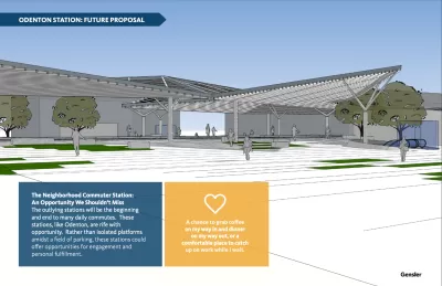
The regional rail transit plans first emerged earlier this year, but Lazo's coverage in The Washington Post will serve to raise public awareness about the effort after the Greater Washington Partnership last week revealed the "Capital Regional Rail Vision," including a fact sheet, technical report, economic impact brief, equity analysis, and some conceptual work by Gensler to imagine the rider and station experience [pdf].
The plan already has significant backing in Maryland, Virginia, and D.C., according to Lazo.
FULL STORY: New regional rail vision aims to bring D.C., Maryland and Virginia closer together. But can it happen?


A Regional Vision for Virginia, Maryland, D.C. Rail
Expanding rail service to more communities in Maryland and D.C. could enhance the benefits of Virginia's recent investments in intercity rail.
Amtrak Calls for Expansion, Citing Close to 100 Requests for New Lines
The agency told a House committee it has received more than 90 applications for new intercity rail lines from cities around the country.
How Virginia Became a Leader in Passenger Rail
The state's consistent investment in passenger rail has resulted in one of the nation's most effective regional rail networks.

Planetizen Federal Action Tracker
A weekly monitor of how Trump’s orders and actions are impacting planners and planning in America.

Map: Where Senate Republicans Want to Sell Your Public Lands
For public land advocates, the Senate Republicans’ proposal to sell millions of acres of public land in the West is “the biggest fight of their careers.”

Restaurant Patios Were a Pandemic Win — Why Were They so Hard to Keep?
Social distancing requirements and changes in travel patterns prompted cities to pilot new uses for street and sidewalk space. Then it got complicated.

Platform Pilsner: Vancouver Transit Agency Releases... a Beer?
TransLink will receive a portion of every sale of the four-pack.

Toronto Weighs Cheaper Transit, Parking Hikes for Major Events
Special event rates would take effect during large festivals, sports games and concerts to ‘discourage driving, manage congestion and free up space for transit.”

Berlin to Consider Car-Free Zone Larger Than Manhattan
The area bound by the 22-mile Ringbahn would still allow 12 uses of a private automobile per year per person, and several other exemptions.
Urban Design for Planners 1: Software Tools
This six-course series explores essential urban design concepts using open source software and equips planners with the tools they need to participate fully in the urban design process.
Planning for Universal Design
Learn the tools for implementing Universal Design in planning regulations.
Heyer Gruel & Associates PA
JM Goldson LLC
Custer County Colorado
City of Camden Redevelopment Agency
City of Astoria
Transportation Research & Education Center (TREC) at Portland State University
Camden Redevelopment Agency
City of Claremont
Municipality of Princeton (NJ)