


In Houston, 60 percent of serious automobile crashes occur on 6 percent of the city's streets. A New Vision Zero Action Plan will focus safety improvements on those streets with a high density of traffic deaths and serious injuries.
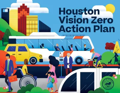
The city of Houston this week launched a new Vision Zero Action Plan (VZAP) "to end traffic deaths and serious injuries by 2030 and improve street safety and equity for road users of all ages, abilities and modes of transportation," according to a press release from the office of Mayor Sylvester Turner.
"More than 200 people die and nearly 1,000 people are seriously injured in crashes on Houston roadways every year," according to the press release.
The launch of the VZAP comes over a year after the city committed to Vision Zero. "After extensive data analysis, community engagement and multiagency collaboration, the City of Houston created the Vision Zero Action Plan."
According to the press release, that analysis included mapping out rates of fatalities and serious injuries in traffic collisions.
The city's Planning and Development Department will spearhead the coalition of city and regional agencies tasked with four key goals to achieve Vision Zero: 1) create a safe, equitable, and accessible network of streets, 2) make walking, rolling, and biking safe, 3) make connecting to transit safe, and 4) make driving safe.
FULL STORY: Mayor Turner launches Vision Zero Action Plan to eliminate traffic deaths in Houston by 2030

NYC Pedestrian Deaths Rose in 2024
The city’s Vision Zero efforts seem to have stalled.
Portland Traffic Deaths Surpass 2022 Number
This year, 69 people have died in traffic crashes in Portland, Oregon, nearly twice as many as in 2018, when the city began its Vision Zero program.
Audit: Portland’s Vision Zero Needs More Data, Funding
A city audit found that the program has failed to reduce traffic deaths and could benefit from a more systematic approach. Meanwhile, PBOT says it needs more state funding to support road safety projects.

Planetizen Federal Action Tracker
A weekly monitor of how Trump’s orders and actions are impacting planners and planning in America.

Map: Where Senate Republicans Want to Sell Your Public Lands
For public land advocates, the Senate Republicans’ proposal to sell millions of acres of public land in the West is “the biggest fight of their careers.”

Restaurant Patios Were a Pandemic Win — Why Were They so Hard to Keep?
Social distancing requirements and changes in travel patterns prompted cities to pilot new uses for street and sidewalk space. Then it got complicated.

Platform Pilsner: Vancouver Transit Agency Releases... a Beer?
TransLink will receive a portion of every sale of the four-pack.

Toronto Weighs Cheaper Transit, Parking Hikes for Major Events
Special event rates would take effect during large festivals, sports games and concerts to ‘discourage driving, manage congestion and free up space for transit.”

Berlin to Consider Car-Free Zone Larger Than Manhattan
The area bound by the 22-mile Ringbahn would still allow 12 uses of a private automobile per year per person, and several other exemptions.
Urban Design for Planners 1: Software Tools
This six-course series explores essential urban design concepts using open source software and equips planners with the tools they need to participate fully in the urban design process.
Planning for Universal Design
Learn the tools for implementing Universal Design in planning regulations.
Heyer Gruel & Associates PA
JM Goldson LLC
Custer County Colorado
City of Camden Redevelopment Agency
City of Astoria
Transportation Research & Education Center (TREC) at Portland State University
Camden Redevelopment Agency
City of Claremont
Municipality of Princeton (NJ)