


An additional benefit of the 14th Street Busway project in Manhattan has emerged: greatly reduced traffic collision rates.
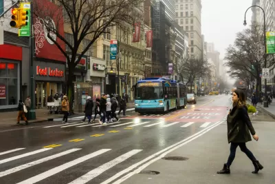
Gersh Kuntzman writes: "The car-free 14th Street Busway is a real lifesaver. No, literally."
The benefits of the city’s transit-priority pilot program between Third and Ninth avenues in Manhattan are well documented: buses are moving much faster and ridership is up as a result of the improved service.
But the project is having a much greater, and much-less-heralded, safety impact.
The article includes data comparing the period from the busway's opening in October 2019 to January 2020 with the same period from the previous year. The difference is drastic.
"In the four months since the busway began in October, total crashes are down 53 percent and injuries are down 63 percent compared to the same four-month period a year earlier," according to Kuntzman. The article concludes with an appeal to deliver the same kind of safety benefits to additional congested, dangerous corridors around the city.
FULL STORY: The ‘Busway’ Proves Another Benefit of Car-Free Streets: Safety

NYC Pedestrian Deaths Rose in 2024
The city’s Vision Zero efforts seem to have stalled.
NYC Sees 127 Traffic Deaths in First Half of 2024
The number is the highest since the city pledged to end traffic deaths through Vision Zero policies a decade ago.
NYC’s Vision Zero Program Saved $90 Million in Medicaid Costs
While traffic fatalities remain far above zero, the city saw fewer injuries compared to areas without Vision Zero initiatives.

Planetizen Federal Action Tracker
A weekly monitor of how Trump’s orders and actions are impacting planners and planning in America.

Restaurant Patios Were a Pandemic Win — Why Were They so Hard to Keep?
Social distancing requirements and changes in travel patterns prompted cities to pilot new uses for street and sidewalk space. Then it got complicated.

Map: Where Senate Republicans Want to Sell Your Public Lands
For public land advocates, the Senate Republicans’ proposal to sell millions of acres of public land in the West is “the biggest fight of their careers.”

Maui's Vacation Rental Debate Turns Ugly
Verbal attacks, misinformation campaigns and fistfights plague a high-stakes debate to convert thousands of vacation rentals into long-term housing.

San Francisco Suspends Traffic Calming Amidst Record Deaths
Citing “a challenging fiscal landscape,” the city will cease the program on the heels of 42 traffic deaths, including 24 pedestrians.

California Homeless Arrests, Citations Spike After Ruling
An investigation reveals that anti-homeless actions increased up to 500% after Grants Pass v. Johnson — even in cities claiming no policy change.
Urban Design for Planners 1: Software Tools
This six-course series explores essential urban design concepts using open source software and equips planners with the tools they need to participate fully in the urban design process.
Planning for Universal Design
Learn the tools for implementing Universal Design in planning regulations.
Heyer Gruel & Associates PA
JM Goldson LLC
Custer County Colorado
City of Camden Redevelopment Agency
City of Astoria
Transportation Research & Education Center (TREC) at Portland State University
Camden Redevelopment Agency
City of Claremont
Municipality of Princeton (NJ)