Better integration between San Diego's various transit modes—trolley (light rail), bus, bus rapid transit, and active transit—are key to increasing use and housing options, argues AVRP planner Howard Blackson III.


Unlike POTUS, San Diego's Republican mayor, Kevin Faulconer, was able to have a state of the union address as scheduled. Well actually a state of the city address. Faulconer is a Republican who is no fan of "The Wall." Additionally, Faulconer actually believes in climate change, and more importantly is addressing it. Under Faulconer, the city has an aggressive Climate Action Plan. Increased use of transit is a key component.
Lack of affordable housing is a big problem in California and San Diego is no exception. San Diego has made efforts to increase housing density and to lift height restrictions near transit stations. However, these plans encountered vigorous neighborhood resistance on housing planned near a new station along the Mid-Coast extension of San Diego's "Trolley" light rail network.
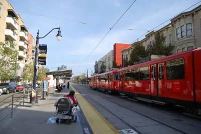
Another problem is that San Diego's Trolley has used mostly existing rail rights-of-way to save cost. But this strategy has placed most trolley stations in sub-optimal locations, i.e., outside of walkable reach of neighborhoods. Blackson explains,
The problem today is that our Trolley acts like Commuter Rail by linking downtown to Santee and the border, as well as acting like a Streetcar by linking downtown’s Little Italy to Gaslamp. No matter where it is in the city, the trolley stops every 15 minutes at over 56 stations. Plus, it is limited in its ability to climb hillsides to access and serve the neighborhoods and districts located on our mesas.
He goes on to explain that the city's new bus rapid transit system is also compromised,
Our city’s new Rapid Bus service is essentially an Express Bus, or BRT-Lite, that flows with traffic, stopping at streetlights, and merging with all traffic on the freeways with 15-minute waits between buses.
Blackson argues that these and other transit modes used or planned by the city must be better integrated to increase ridership and compliment increased housing. He suggests moving away from the traditional model of buses as LRT feeder lines to a model in which BRT is more an expansion of LRT, so that it works more like LRT is supposed to work. Buses and streetcar lines can be used to connect neighborhoods and—together with LRT and BRT—to create an effective walkable multi-hub transit system.
See the source article for Blackson's "hierarchy" of transit modes.
Read the full story: How to Achieve Walkable Transit Service in San Diego!

San Diego Regional Transportation Plan Shifts Away From Big Projects to Focus on Improving Existing Infrastructure
SANDAG’s 2025 Regional Plan scales down plans for new rail lines in favor of expanding rapid bus service.

Miami to Launch America's First Fully Electric Bus Rapid Transit Line
The project, led by Miami-Dade County, will link Dadeland South to Florida City via a 20-mile dedicated lane.
Houston Could Cancel Rapid Transit Project
Metro officials say prioritizing the University Corridor project would force them to delay or cancel other service expansion initiatives.

Planetizen Federal Action Tracker
A weekly monitor of how Trump’s orders and actions are impacting planners and planning in America.

California plans to bury El Niño’s downpour
If the state plays its cards right, it may be able to store a billion acre-feet of El Niño’s water in aquifers.

Chicago breaks ground on $3 billion megadevelopment
The new neighborhood, titled Foundry Park, will one day host 3,700 residences.

Satanic Place Names
From streams and lakes to valleys and canyons, I mapped more than 1,000 places named after the Devil.

California High-Speed Rail Authority CEO resigns after $600,000 scandal
Under Ian Choudri, the authority used taxpayer dollars to fund first class flights and trips to nightclubs.

Want to study the Missouri River? Soon, you may need unanimous approval from 10 states
Legislation would require 10 governors’ permission to study or build projects moving water outside the basin.

FREE Course: Walkable City 1: Why Walkability?
After describing his path towards focusing on walkability as the essence of good planning, Jeff Speck marches through his five principal reasons for making more walkable places.
Reinventing Malls: Planning Alchemy—Turning Gray Fields Into Gold
The course focuses on the opportunities and imperatives that shape reinvention of mall sites.

City of Rosemead
Rutgers University, Edward J. Bloustein School of Planning and Public Policy
One Hundred Miles
Hunter College, City University of New York (CUNY)
The Architects Foundation
University of Cincinnati Online
City of Cambridge
Montrose County
The Pocatello Development Authority