


Plans to extend Milwaukee's The Hop streetcar line are still years away from fruition, but the city is already at work on development plans to make the most of the opportunity.
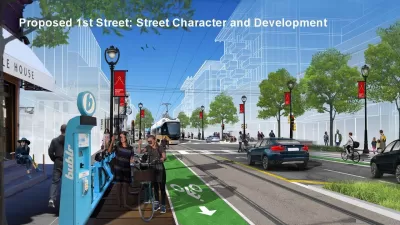
"While the actual extension of The Hop to the north and south is likely years away, the city has completed a planning process to study what development around stops in Bronzeville and Walker’s Point should look like," reports Jeramey Jannene.
The Department of City Development presented the transit oriented development plan to the City Plan Commission earlier this week. The plan is designed "to extend investment from Downtown, connecting neighborhoods physically and economically, to enhance the local distinctiveness of neighborhoods and ensure that the existing communities benefit from any extensions through equitable and inclusive strategies," according to Jannene. To take effect, the new transit oriented development plans would be incorporated into area plans for Walker's Point and Bronzeville.
The plan prepared for Walker’s Point includes 1,500 to 2,000 new homes (primarily through multi-family buildings), 10 to 20 new storefronts and 3,000 to 4,000 new jobs primarily through the creation of new office space throughout the corridor.
The Bronzeville plan envisions 1,500 to 2,000 new homes, 20 to 30 new storefronts and 1,500 to 2,500 new jobs. The plan also envisions up to four new community facilities in the corridor. Most of the development is envisioned to happen near two intersections, where N. Martin Luther King Jr. Dr. intersects with W. North Ave. and with W. McKinley Ave. Both intersections have seen increased development in recent years including the Bucks arena district just south of W. McKinley Ave. and a host of projects along W. North Ave. including the Pete’s Fruit Market grocery store and The Griot apartments.
Those kinds of goals would require increased building heights. Skidmore, Owings and Merrill is the lead consultant on the plan. A lot more details are included in the source article.
FULL STORY: New Development Plans for Streetcar


Project Team for Milwaukee's New Downtown Area Plan Takes Shape
A new plan for Milwaukee's downtown will build on a "major renaissance" in the area since the approval of the last version of the plan in 2010.

Downtown Milwaukee Area Plan Update Kicks Off
Billions of dollars in investment and thousands of new residential units later, Milwaukee is ready to update the plan for its downtown.

'The Hop' Streetcar Opens to the Public Today in Milwaukee
The Hop will deliver new transit service on the east side of downtown Milwaukee. The Hop comes also serves big development expectations from local officials.

Planetizen Federal Action Tracker
A weekly monitor of how Trump’s orders and actions are impacting planners and planning in America.

Map: Where Senate Republicans Want to Sell Your Public Lands
For public land advocates, the Senate Republicans’ proposal to sell millions of acres of public land in the West is “the biggest fight of their careers.”

Restaurant Patios Were a Pandemic Win — Why Were They so Hard to Keep?
Social distancing requirements and changes in travel patterns prompted cities to pilot new uses for street and sidewalk space. Then it got complicated.

Platform Pilsner: Vancouver Transit Agency Releases... a Beer?
TransLink will receive a portion of every sale of the four-pack.

Toronto Weighs Cheaper Transit, Parking Hikes for Major Events
Special event rates would take effect during large festivals, sports games and concerts to ‘discourage driving, manage congestion and free up space for transit.”

Berlin to Consider Car-Free Zone Larger Than Manhattan
The area bound by the 22-mile Ringbahn would still allow 12 uses of a private automobile per year per person, and several other exemptions.
Urban Design for Planners 1: Software Tools
This six-course series explores essential urban design concepts using open source software and equips planners with the tools they need to participate fully in the urban design process.
Planning for Universal Design
Learn the tools for implementing Universal Design in planning regulations.
Heyer Gruel & Associates PA
JM Goldson LLC
Custer County Colorado
City of Camden Redevelopment Agency
City of Astoria
Transportation Research & Education Center (TREC) at Portland State University
Camden Redevelopment Agency
City of Claremont
Municipality of Princeton (NJ)