


When the line shuts down for repairs next year, an uptick in cycling is expected. Infrastructure improvements will make this shift easier and could promote biking well into the future.
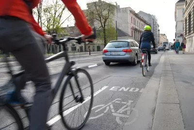
Aaron Gordon considers the effects the L train shutdown will have on cycling in New York. The line is scheduled to go offline for repairs starting in the spring of 2019. Predictions indicate that two percent of riders, about 4,500 riders, will move over to biking, and almost half to three-quarters of them will be using the Williamsburg Bridge, reports Gordon.
In anticipation of this increase in cyclists, the New York City Department of Transportation is proposing a series of road improvements, including better connections to the Williamsburg Bridge and protected bike lanes in the area.
But not all the changes have been well received, says Gordon. A plan for a two-way protected bike lane along 14th Street was met with resistance from residents. Now two one-way bike lanes are planned for 12th and 13th Streets, which disappointed bike advocates who were hoping for the safer two-lane design and a crosstown route that would encourage cycling.
A shift to cycling is critical and it benefits all travelers, argues Gordon. Otherwise, he says, traffic will worsen as the number of ride-hailing vehicles increases and other transit modes reach capacity. “And the more people who regularly bike, the louder the calls will be for safer, protected infrastructure. And maybe, just maybe, this positive cycle will continue after the L resumes rumbling under the river,” adds Gordon.
FULL STORY: Why biking is critical for surviving the L train shutdown

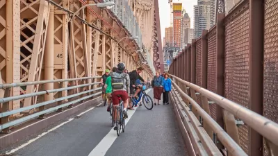
Bike Traffic Up 88 Percent On New Brooklyn Bridge Bike Lane
Bike ridership nearly doubled after New York City installed a new bike lane on the Brooklyn Bridge.

Signal Priority in N.Y.C. to Make Streets Safer for Cyclists
New York City will create green waves by adjusting traffic signals to keep cyclists moving, even when drivers will have to slow down.
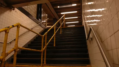
$5.5 Billion Plan for More Elevators in the N.Y.C. Subway
The city’s subway system is lagging in station accessibility, but the MTA has a plan to add elevators to 70 stations.

Planetizen Federal Action Tracker
A weekly monitor of how Trump’s orders and actions are impacting planners and planning in America.

Map: Where Senate Republicans Want to Sell Your Public Lands
For public land advocates, the Senate Republicans’ proposal to sell millions of acres of public land in the West is “the biggest fight of their careers.”

Restaurant Patios Were a Pandemic Win — Why Were They so Hard to Keep?
Social distancing requirements and changes in travel patterns prompted cities to pilot new uses for street and sidewalk space. Then it got complicated.

Platform Pilsner: Vancouver Transit Agency Releases... a Beer?
TransLink will receive a portion of every sale of the four-pack.

Toronto Weighs Cheaper Transit, Parking Hikes for Major Events
Special event rates would take effect during large festivals, sports games and concerts to ‘discourage driving, manage congestion and free up space for transit.”

Berlin to Consider Car-Free Zone Larger Than Manhattan
The area bound by the 22-mile Ringbahn would still allow 12 uses of a private automobile per year per person, and several other exemptions.
Urban Design for Planners 1: Software Tools
This six-course series explores essential urban design concepts using open source software and equips planners with the tools they need to participate fully in the urban design process.
Planning for Universal Design
Learn the tools for implementing Universal Design in planning regulations.
Heyer Gruel & Associates PA
JM Goldson LLC
Custer County Colorado
City of Camden Redevelopment Agency
City of Astoria
Transportation Research & Education Center (TREC) at Portland State University
Camden Redevelopment Agency
City of Claremont
Municipality of Princeton (NJ)