


The extended tollway would cut beyond the Urban Growth Boundary into the Everglades.
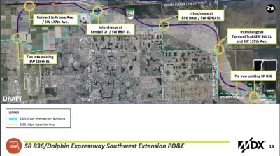
According to Jay Koziarz, "a controversial plan to extend the Dolphin Expressway through the Everglades to West Kendall was OK’d by Miami-Dade commissioners on Thursday by a 9-4 vote."
The project will add 13 miles of tollway on land located beyond the Urban Development Boundary established to protect this corner of the Everglades.
Despite the decision by Miami-Dade commissioners to approve the preliminary plan for the extended expressway, there's still a lot of ground to cover before the project is ready to break ground. Koziarz explains:
Despite winning over the majority of commissioners and appearing to be a forgone conclusion, the project still needs to secure state, federal, and Department of Environmental Resources Management permits. Meanwhile, the county’s new “sexy highway” could potentially face some not-so-sexy lawsuits. Stay tuned.
Another article written by Jenny Staletovich just before the commission's vote digs into the lack of a solid route plan for the project. "In a legal notice published in advance of the hearing last week, the county included a map depicting an eastern route. Commissioners’ application packet, however, contains a map with the route to the west," writes Staletovich. Opponents of the project seized on the lack of detail and transparency as the commission considered the plan.
FULL STORY: Miami-Dade approves Dolphin Expressway extension through the Everglades


California Environmental Leaders Call on State Agencies to Prioritize Multimodal Transportation
Even before President Trump took office, California was not meeting its emissions reduction goals.
Opinion: LA Should Reject ‘Misguided’ Car-Centric Policies
Even as the city highlights clean energy and transportation for the 2028 Olympics, Metro and Caltrans move forward with plans to expand highways.
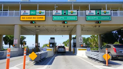
Florida to Provide Toll Relief for Frequent Commuters
It will be cheaper to drive around Florida, starting January 1.

Planetizen Federal Action Tracker
A weekly monitor of how Trump’s orders and actions are impacting planners and planning in America.

Map: Where Senate Republicans Want to Sell Your Public Lands
For public land advocates, the Senate Republicans’ proposal to sell millions of acres of public land in the West is “the biggest fight of their careers.”

Restaurant Patios Were a Pandemic Win — Why Were They so Hard to Keep?
Social distancing requirements and changes in travel patterns prompted cities to pilot new uses for street and sidewalk space. Then it got complicated.

Platform Pilsner: Vancouver Transit Agency Releases... a Beer?
TransLink will receive a portion of every sale of the four-pack.

Toronto Weighs Cheaper Transit, Parking Hikes for Major Events
Special event rates would take effect during large festivals, sports games and concerts to ‘discourage driving, manage congestion and free up space for transit.”

Berlin to Consider Car-Free Zone Larger Than Manhattan
The area bound by the 22-mile Ringbahn would still allow 12 uses of a private automobile per year per person, and several other exemptions.
Urban Design for Planners 1: Software Tools
This six-course series explores essential urban design concepts using open source software and equips planners with the tools they need to participate fully in the urban design process.
Planning for Universal Design
Learn the tools for implementing Universal Design in planning regulations.
Heyer Gruel & Associates PA
JM Goldson LLC
Custer County Colorado
City of Camden Redevelopment Agency
City of Astoria
Transportation Research & Education Center (TREC) at Portland State University
Camden Redevelopment Agency
City of Claremont
Municipality of Princeton (NJ)