


There are solutions to slow, unreliable bus service. These local buses don't have any of those solutions going for them.
Will Bredderman spreads the ignominy for a chosen few bus routes in New York City.
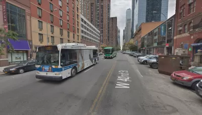
Transit advocacy groups Straphangers Campaign and TransitCenter released a report detailing the slowest buses in the city. The slowest bus in the entire city is awarded the "Pokey." The winner of the 2018 Pokey is M42, which the report finds averaging a speed of 3.2 miles per hour. For comparison, a press release announcing the award [pdf] notes that a chicken can run 9 miles per hour.
The report also announces the "Schleppie," awarded to the bus route observed bunching (defined here as two or more buses arrive at a stop at the same time) as a proxy for being unreliable. The 2018 Schleppie Award goes to the B12, observed with a 21.4 percent bunching rate.
Bredderman also notes the measures transit advocates would implement to improve both slow speeds and unreliability.
FULL STORY: Worst bus lines are in Midtown and central Brooklyn, report finds

Popular L.A. Bus Line to Replace Schedule With ‘Headway-Based Operations’
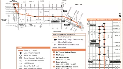
Los Angeles’ 16 bus, which cuts across the city on Third Street through some of the city’s densest neighborhoods, will experiment with a new approach to service design.
New York MTA Committed to Improving Bus Bunching
The New York MTA is on a mission to mitigate bus bunching, the telltale sign of unreliable service.
In New York: No Bus Ridership Without Congestion Relief
Bus ridership has dropped for many years in New York City, but much of the bleeding is concentrated in Manhattan and Brooklyn. Could the congestion problems of the central city be the reason for the declining use of bus transit?

Planetizen Federal Action Tracker
A weekly monitor of how Trump’s orders and actions are impacting planners and planning in America.

Map: Where Senate Republicans Want to Sell Your Public Lands
For public land advocates, the Senate Republicans’ proposal to sell millions of acres of public land in the West is “the biggest fight of their careers.”

Restaurant Patios Were a Pandemic Win — Why Were They so Hard to Keep?
Social distancing requirements and changes in travel patterns prompted cities to pilot new uses for street and sidewalk space. Then it got complicated.

Platform Pilsner: Vancouver Transit Agency Releases... a Beer?
TransLink will receive a portion of every sale of the four-pack.

Toronto Weighs Cheaper Transit, Parking Hikes for Major Events
Special event rates would take effect during large festivals, sports games and concerts to ‘discourage driving, manage congestion and free up space for transit.”

Berlin to Consider Car-Free Zone Larger Than Manhattan
The area bound by the 22-mile Ringbahn would still allow 12 uses of a private automobile per year per person, and several other exemptions.
Urban Design for Planners 1: Software Tools
This six-course series explores essential urban design concepts using open source software and equips planners with the tools they need to participate fully in the urban design process.
Planning for Universal Design
Learn the tools for implementing Universal Design in planning regulations.
Heyer Gruel & Associates PA
JM Goldson LLC
Custer County Colorado
City of Camden Redevelopment Agency
City of Astoria
Transportation Research & Education Center (TREC) at Portland State University
Camden Redevelopment Agency
City of Claremont
Municipality of Princeton (NJ)