


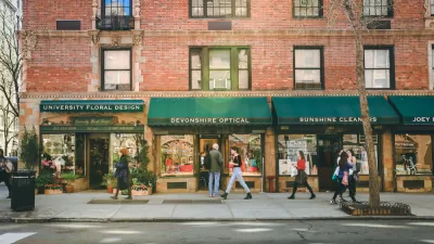
Baltimore has a lot of bold ideas for changing the face of the city. While we wait for them to happen, why not implement some simple solutions for making the city more livable, proposes Mark R. Brown, AICP.
Brown suggests six solutions that Baltimore, or any city for that matter, "can do right now to make people say, 'Hey, this place is alright'." His list includes: low cost transit improvements, 20 mph neighborhood zones, complete streets, small public plazas, and street art (which as the video below shows, it already does quite well).
The final element - positive street life, says Brown, is a result of the rest. "Getting off the train from DC into downtown Baltimore is disheartening and a buzz kill. Aside from the sorry state of Penn Station, most of this has to do with how abandoned our streets are, even during lunch and dinner hours. Streets are people’s first impression of a city, and when they’re filled solely with cars rushing by on wide one way streets at 45mph, it says something negative about our city. Go to NYC. Go to Philly. Go to DC or even parts of Pittsburgh and see how their streets are also outdoor performance theaters, playgrounds, cultural conduits, window shopping opportunities, and bicycle skyways. A quality street does more than one thing well. A street that does many things well becomes magical."
FULL STORY: Ways We Can Make Baltimore More Livable Right Now


Meet NYC’s New Office of Livable Streets
The NYC DOT program will build on pandemic-era initiatives to promote safe and comfortable streets that enhance community and expand uses beyond just moving cars.
Livable Streets, Revisited
The updated version of Donald Appleyard’s 1982 book Livable Streets, written by Appleyard's son, dives even deeper into the ‘ecology of the street,’ proposing actionable solutions for the conflicts and problems facing urban environments today.
Protected Bike Lanes, Vehicle Lane Reductions Cause Stir in Baltimore
Residents and business operators say they weren’t warned about a road diet planned for a major thoroughfare in Baltimore. Planners and advocates say the changes have been a long time coming.

Planetizen Federal Action Tracker
A weekly monitor of how Trump’s orders and actions are impacting planners and planning in America.

Map: Where Senate Republicans Want to Sell Your Public Lands
For public land advocates, the Senate Republicans’ proposal to sell millions of acres of public land in the West is “the biggest fight of their careers.”

Restaurant Patios Were a Pandemic Win — Why Were They so Hard to Keep?
Social distancing requirements and changes in travel patterns prompted cities to pilot new uses for street and sidewalk space. Then it got complicated.

Platform Pilsner: Vancouver Transit Agency Releases... a Beer?
TransLink will receive a portion of every sale of the four-pack.

Toronto Weighs Cheaper Transit, Parking Hikes for Major Events
Special event rates would take effect during large festivals, sports games and concerts to ‘discourage driving, manage congestion and free up space for transit.”

Berlin to Consider Car-Free Zone Larger Than Manhattan
The area bound by the 22-mile Ringbahn would still allow 12 uses of a private automobile per year per person, and several other exemptions.
Urban Design for Planners 1: Software Tools
This six-course series explores essential urban design concepts using open source software and equips planners with the tools they need to participate fully in the urban design process.
Planning for Universal Design
Learn the tools for implementing Universal Design in planning regulations.
Heyer Gruel & Associates PA
JM Goldson LLC
Custer County Colorado
City of Camden Redevelopment Agency
City of Astoria
Transportation Research & Education Center (TREC) at Portland State University
Camden Redevelopment Agency
City of Claremont
Municipality of Princeton (NJ)