


Residents and business operators say they weren’t warned about a road diet planned for a major thoroughfare in Baltimore. Planners and advocates say the changes have been a long time coming.
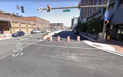
“Work is wrapping up on a $55 million, yearslong upgrade of a major downtown roadway serving Baltimore’s developing waterfront neighborhoods,” reports Lorraine Mirabella in a paywalled article for the Baltimore Sun. “But the revitalization of Central Avenue’s streetscape has surprised some business operators and residents.”
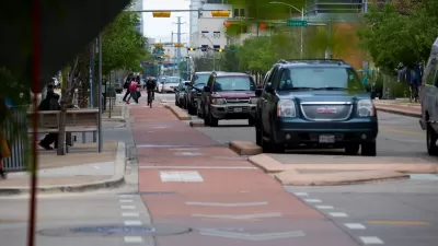
Based on the article’s telling of the story, some local businesses and residents were expecting the project to add vehicle capacity—instead the project is eliminating a vehicle lane in each direction and adding a protected bicycle path. Doug Schmidt, a principal with Workshop Development, is quoted in the article saying the “road diet” was never made public.
“Opponents fear the rebuilt road won’t handle current traffic or heavier use as workers return to offices and as new apartments, offices, hotels and stores open in the corridor. They worry about safety, loss of parking, disruption to businesses that rely on loading areas and increased congestion on neighborhood streets,” writes Mirabella.
Proponents, including bike and complete streets advocates, support the changes. The article notes that the political conflict is indicative of similar struggles in other cities—where increasing awareness of traffic safety and climate change is butting heads with the car-centric planning status quo.
The article documents the planning process that produced the road diet for Central Avenue. The process dates back to 2015, with more direct changes implemented by the city’s adoption of a complete streets ordinance in 2018 and public outreach in November 2021.
FULL STORY: Controversy emerges over changes to Baltimore’s Central Avenue streetscape as it nears completion

Austin Outlaws Blocking Bike Lanes
Drivers who park in bike lanes will receive citations of up to $300.
Why a Complete Streets Makeover Went Awry in Philadelphia
The city pulled the plug on a proposed street redesign after community groups criticized the public engagement process for not listening to all local voices.
The Post-Bikelash Era?
Building protected bike lanes in Canada isn't as controversial as it once was. Maybe there's hope for the United States?

Planetizen Federal Action Tracker
A weekly monitor of how Trump’s orders and actions are impacting planners and planning in America.

Maui's Vacation Rental Debate Turns Ugly
Verbal attacks, misinformation campaigns and fistfights plague a high-stakes debate to convert thousands of vacation rentals into long-term housing.

San Francisco Suspends Traffic Calming Amidst Record Deaths
Citing “a challenging fiscal landscape,” the city will cease the program on the heels of 42 traffic deaths, including 24 pedestrians.

Defunct Pittsburgh Power Plant to Become Residential Tower
A decommissioned steam heat plant will be redeveloped into almost 100 affordable housing units.

Trump Prompts Restructuring of Transportation Research Board in “Unprecedented Overreach”
The TRB has eliminated more than half of its committees including those focused on climate, equity, and cities.

Amtrak Rolls Out New Orleans to Alabama “Mardi Gras” Train
The new service will operate morning and evening departures between Mobile and New Orleans.
Urban Design for Planners 1: Software Tools
This six-course series explores essential urban design concepts using open source software and equips planners with the tools they need to participate fully in the urban design process.
Planning for Universal Design
Learn the tools for implementing Universal Design in planning regulations.
Heyer Gruel & Associates PA
JM Goldson LLC
Custer County Colorado
City of Camden Redevelopment Agency
City of Astoria
Transportation Research & Education Center (TREC) at Portland State University
Jefferson Parish Government
Camden Redevelopment Agency
City of Claremont