


Shared streets
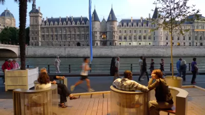
Paris Tests a New Approach to Urban Space
Any visitor from America would think that Paris had found the solution to creating great public spaces and taming the automobile. But the city's new approach to urban space suggests city leaders and residents feel otherwise.
Safeguarding New York's Most Vulnerable Neighborhood
While Staten Island and Rockaway, Queens also suffered devastation from Superstorm Sandy; Broad Channel, an island in Jamaica Bay, Queens, may be the lowest lying area in the City and endures tidal flooding regularly, not just from storm surges.
Removing Sidewalks to Make Room for Peds
WAMU's Michael Pope reports on an Alexandria, VA's plan to level the playing field for bikes, pedestrians and cars by taking out curbs.
London Experiments With Shared Streets
It may seem counter-intuitive, but "shared space" advocates say cars and bikes will get in fewer accidents if barriers and traffic lane markets are removed. London's Exhibition Road will open next month using this design concept.
Urbanism Without Effort
Chuck Wolfe says that urbanism that can readily occur in urban neighborhoods "without really trying" as people naturally come together in impromptu ways.
Fusion Businesses as Indicators of Urban Change
Chuck Wolfe explains how the fusion of laundromats and dining are evidence of the evolving city and the ongoing need for regulatory reform.
Jan Gehl on Safety
Want to prevent crime and keep people safe in traffic? Jan Gehl says the solution is to mix up pedestrians, bikes and cars into "shared spaces."
How Shared Space Challenges Conventional Thinking about Transportation Design
Shared streets -- the idea that pedestrians, bikes and cars can all navigate together in the same space -- is a fundamental rethinking of the underlying philosophy related to the design and operation of transportation facilities, write Norman W. Garrick and James G. Hanley.
Britons Move Towards A New Era of "Civilized Street Design"
Designers and "movement specialists" in Great Britain are pioneering various street designs that aim to bring traffic speeds down to teens, which they claim is the speed range that allows vehicles to safely share a space with pedestrians.
A Woonerf in Harvard Square
English architect Ben Hamilton-Baillie sees possibility in a section of Harvard Square that has all the qualities of a "woonerf"; mainly, that cars, bikes and pedestrians all share the street equally.
de facto Shared Streets
Shared streets, the contemporary vernacular used to describe streets that have been intentionally redesigned to remove exclusive boundaries for pedestrians, bicyclists, cars, etc., work well within a special set of conditions. It is, in reality, just a new way of describing the original use of streets (see this previous post for more on that). The most promising candidates for shared streets are those where traffic volumes are not too heavy, the route is not a critical corridor for vehicular through-traffic, activities and attractions along the street are plentiful, short distance connectivity is viable, and a critical mass of pedestrians (perhaps enough to pack sidewalks at certain times) exists. A shared street may also be suitable in places where there is a desire to induce such conditions; however, care must be taken to understand the larger network effects of shifting or slowing down vehicular traffic. But in some instances, seemingly unrelated changes to traffic patterns or the effects of a coincidental collection of the above conditions sometimes go unnoticed until a street that may have been all about cars gradually shifts into something I refer to as a “de facto shared street”.
Streets Are For People, Not (Just) Cars
At a company presentation about environmental impact the other week a colleague included a historic photograph of Scollay Square in Boston. You are pardoned if, even after visiting or living in that city, this doesn’t sound familiar because all prominent characteristics of the area were summarily obliterated in the mid-twentieth century to make way for a potpourri of brutalist-style administrative buildings and renamed Government Center. Urban redevelopment arguments aside, the photograph reveals a particularly interesting detail about the function and use of streets virtually erased from our minds over the last century.
Urban Design for Planners 1: Software Tools
This six-course series explores essential urban design concepts using open source software and equips planners with the tools they need to participate fully in the urban design process.
Planning for Universal Design
Learn the tools for implementing Universal Design in planning regulations.
Smith Gee Studio
City of Charlotte
City of Camden Redevelopment Agency
City of Astoria
Transportation Research & Education Center (TREC) at Portland State University
US High Speed Rail Association
City of Camden Redevelopment Agency
Municipality of Princeton (NJ)


