


Google Maps

Planetizen Week in Review: August 1, 2016
Political junkies, map nerds, and transit fans all got plenty of big news to digest during the last week of July 2016.
Google Maps Adds New 'Areas of Interest' Overlay
A new Google Maps redesign hopes to help make it easier to explore your surroundings. As with everything based on a mobile phone, the potential exists that it might also help ignore your surroundings.
Changes to Google Maps Don't Necessarily Equal Good Cartography
Google Maps has changed a lot since its quick rise to ubiquity. An intrepid blogger digs into the nitty gritty of how the mapping platform has changed, and the consequences of Google's cartography for how the public perceives the world.
Getting Residents Engaged in Participatory Mapping
Participatory mapping has become an increasingly popular planning tool. The examples that follow highlight how communities are using participatory mapping.
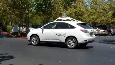
On the Self-Driving Car's Taste in Maps
The navigational software of successful driverless cars will make Google Maps seem like child's play. But can such a system replace or improve upon human instinct and adaptability?
How Google Maps Gets the 'Ground Truth' for Street View
A peak under the hood at "Ground Truth"—the operation behind Google Street View.
The Race to Map Brazil's Favelas
In an effort to tap into new users, companies like Google and Microsoft are racing to map the winding, informal streets of Brazil's slums in Rio de Janeiro.
Does the Evolution of Smartphones Come at the Expense of 'Spatial Thinking'?
Are smartphones supplementing the capacity of humans to think spatially, such that future generations might lose fundamental cognitive abilities?
Google Maps Methane Leaks in Three U.S. Cities
Google, partnering with the Environmental Defense Fund, has created a series of maps locating methane leaks around three cities in the United States. The question of just how much methane is leaking in a given city comes down to infrastructure.

Friday Funday: New Google Maps Game Tests Your Geography Knowledge
If you're obsessed with trivia and maps, prepare to lose some hours.
Mobile Version of Google Maps Releases New Features
The popularity of Google Maps is well-documented, and as more users are using the software on their phones (remember when you had to print maps before you left your home or office?), Google's recent updates includes a bunch of new mobile features.
Can OpenStreetMap Overthrow the Google Maps Hegemony?
A recent long-read describes the current state of the competition for primacy in the world of online mapping tools. The champ—Google Maps. The challenger—OpenStreetMap.
To Encourage Cycling, Time is of the Essence
What's the best way to get people to bike? "[M]ake clear the costs of not biking, in minutes saved or dollars not spent," writes Emily Badger. A new tool developed by Zach Rausnitz uses Google Maps data to compare travel times of alternative modes.
Google's Photo Share Takes You Where It's Street View Cannot Go
Android app enables users with smartphones to take panoramic photos of remote places to share on Google Photo Sphere.
Will Google Maps Destroy Public Space?
With the latest redesign of Maps, Google is personalizing the mapping experience to reflect the places we, and our friends, frequent. In doing so, will the technology giant eliminate serendipitous "entanglements" from the urban experience?
With Major Redesign, Google Heats Up Online Map Wars
In recent months, new players like Apple and MapBox have taken aim at the increasingly important arena of digital mapping. With the boldest redesign of Google Maps in 8 years launched this week, "the leader in online mapping" isn't standing pat.
A Handy Tool for Making Scale Comparisons
One of the most valuable graphics in the planner's toolbox is the scale comparison. However, producing such graphics can be a tedious process. A web-based tool utilizing Google Maps seeks to make cartographic “mixtures” much easier to produce.
With GE Partnership, Google Maps Goes Underground
GE and Google maps have announced a new partnership that could lead to significant advances in the way infrastructure is planned, cataloged, and maintained, reports Michael V. Copeland.
The Quest to Build the Best Map
Why are Google, Apple, Nokia, and Microsoft funneling significant resources into creating the best digital maps? "[A]ll share the same hunch that maps sit at the core of our digital future," writes Farhad Manjoo.
Who Defines New York's Nabes? For Starters Look to These Amateur Mapmakers
In New York, neighborhood boundaries are big business. Just ask any real estate agent who's tried to pass off a Gowanus apartment as being in Park Slope. Since the city does not officially define boundaries, amateurs are filling the void.
Urban Design for Planners 1: Software Tools
This six-course series explores essential urban design concepts using open source software and equips planners with the tools they need to participate fully in the urban design process.
Planning for Universal Design
Learn the tools for implementing Universal Design in planning regulations.
planning NEXT
Appalachian Highlands Housing Partners
Mpact (founded as Rail~Volution)
City of Camden Redevelopment Agency
City of Astoria
City of Portland
City of Laramie


