


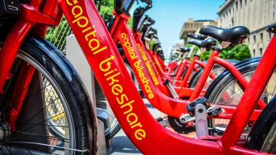
What's the best way to get people to bike? "[M]ake clear the costs of not biking, in minutes saved or dollars not spent," writes Emily Badger. A new tool developed by Zach Rausnitz uses Google Maps data to compare travel times of alternative modes.
A new tool for bike-share users in Washington, D.C. developed by Fierce Government editor Zach Rausnitz takes the comparative approach of Google Maps' direction service to point out how using a bicycle can save both time and money compared to other modes of transportation.
"Rausnitz has used historic data from actual Capital Bikeshare member trips to calculate the average time a ride takes between any two stations in the system (he threw out the crazy outliers in his calculations)," explains Emily Badger.
"This comparison is so powerful – and this is the kind of data any bike-share system needs – for one big reason. It's not enough to make it possible for people to bike. What advocates really need to do is make clear the costs of not biking, in minutes saved or dollars not spent."
FULL STORY: The Simplest Way to Get People Biking


Bikeshare for the Win: Team Pedals to London Cricket Match, Beats Rivals Stuck in Traffic
While their opponents sat in gridlock, England's national cricket team hopped Lime bikes, riding to a 3-0 victory.

Nashville Doesn’t Renew Bike Share Contract, Citing Lost Federal Funding
The city’s bike share system, operated by BCycle, could stop operating if the city doesn’t find a new source of funding.
CaBi Breaks Ridership Record — Again
Washington D.C.’s bike share system is extremely popular with both residents and visitors.

Planetizen Federal Action Tracker
A weekly monitor of how Trump’s orders and actions are impacting planners and planning in America.

Restaurant Patios Were a Pandemic Win — Why Were They so Hard to Keep?
Social distancing requirements and changes in travel patterns prompted cities to pilot new uses for street and sidewalk space. Then it got complicated.

Maui's Vacation Rental Debate Turns Ugly
Verbal attacks, misinformation campaigns and fistfights plague a high-stakes debate to convert thousands of vacation rentals into long-term housing.

In California Battle of Housing vs. Environment, Housing Just Won
A new state law significantly limits the power of CEQA, an environmental review law that served as a powerful tool for blocking new development.

Boulder Eliminates Parking Minimums Citywide
Officials estimate the cost of building a single underground parking space at up to $100,000.

Orange County, Florida Adopts Largest US “Sprawl Repair” Code
The ‘Orange Code’ seeks to rectify decades of sprawl-inducing, car-oriented development.
Urban Design for Planners 1: Software Tools
This six-course series explores essential urban design concepts using open source software and equips planners with the tools they need to participate fully in the urban design process.
Planning for Universal Design
Learn the tools for implementing Universal Design in planning regulations.
Heyer Gruel & Associates PA
JM Goldson LLC
Custer County Colorado
City of Camden Redevelopment Agency
City of Astoria
Transportation Research & Education Center (TREC) at Portland State University
Camden Redevelopment Agency
City of Claremont
Municipality of Princeton (NJ)