


With the latest redesign of Maps, Google is personalizing the mapping experience to reflect the places we, and our friends, frequent. In doing so, will the technology giant eliminate serendipitous "entanglements" from the urban experience?
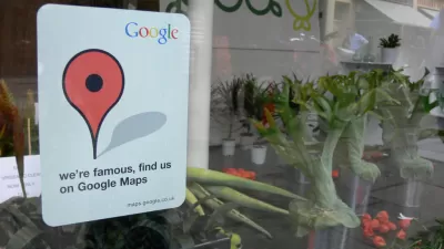
"In the near future (Google says it will 'be rolling it out to more people in the coming days and weeks'), the maps we see will be dynamically generated and highly personalized, giving preferential treatment to the places frequented by our social networking friends, the places we mention in our emails, the sites we look up on the search engine," writes Evgeny Morozov. "Conversely, the places that we haven't encountered—or, at least, haven't yet expressed any interest in encountering—will be harder to find."
"The problem with Google's vision is that it doesn't acknowledge the vital role that disorder, chaos, and novelty play in shaping the urban experience," he continues. "If Google has its way, our public space might soon look like the Californian suburbia that the company calls home: nice but isolated, sunny but relying on decrepit infrastructure, orderly but segregated by income."
Here's one idea for preserving surprise and serendipity in your urban explorations: turn off the smartphone.
FULL STORY: My Map or Yours?


How Public Spaces Exclude Teen Girls
Adolescent girls face unique challenges and concerns when navigating public spaces. We can design cities with their needs in mind.

Quantifying Social Infrastructure
New developments have clear rules for ensuring surrounding roads, water, and sewers can handle new users. Why not do the same for community amenities?
NYC Open Streets Organizers Call for City Support
The number of open streets projects has dropped year after year as volunteer groups struggle to fund and staff them.

Maui's Vacation Rental Debate Turns Ugly
Verbal attacks, misinformation campaigns and fistfights plague a high-stakes debate to convert thousands of vacation rentals into long-term housing.

Planetizen Federal Action Tracker
A weekly monitor of how Trump’s orders and actions are impacting planners and planning in America.

In Urban Planning, AI Prompting Could be the New Design Thinking
Creativity has long been key to great urban design. What if we see AI as our new creative partner?

King County Supportive Housing Program Offers Hope for Unhoused Residents
The county is taking a ‘Housing First’ approach that prioritizes getting people into housing, then offering wraparound supportive services.

Researchers Use AI to Get Clearer Picture of US Housing
Analysts are using artificial intelligence to supercharge their research by allowing them to comb through data faster. Though these AI tools can be error prone, they save time and housing researchers are optimistic about the future.

Making Shared Micromobility More Inclusive
Cities and shared mobility system operators can do more to include people with disabilities in planning and operations, per a new report.
Urban Design for Planners 1: Software Tools
This six-course series explores essential urban design concepts using open source software and equips planners with the tools they need to participate fully in the urban design process.
Planning for Universal Design
Learn the tools for implementing Universal Design in planning regulations.
planning NEXT
Appalachian Highlands Housing Partners
Mpact (founded as Rail~Volution)
City of Camden Redevelopment Agency
City of Astoria
City of Portland
City of Laramie