


GIS
Three Ways to Make GIS as Powerful as Possible
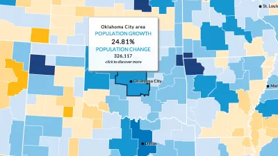
These days, cities are expected to make the most of open data and spatial visualization technologies.

A Land-Management Plan for Catholic Properties Around the World
One of the largest landowners in the world—historically known for creating maps of the Earth—the Church doesn't yet have a cohesive understanding of its global footprint.

Technologies for Understanding Cities
Researchers are examining technologies that can aid in understanding many aspects of our cities, from how citizens interact in plan making, where residents use social media, and how to understand our changing communities.
Teaching Students the Power of GIS
Ninth graders in Soldotna, Alaska, were introduced to geographic information systems (GIS) by a team of volunteers who spent two days illustrating how GIS technology is used in analyzing complex systems.
Visualizing the Spread of the OpenStreetMap Project
OpenStreetMap has released an animated map to illustrate the impressive growth of the project over the first ten years of its existence.

What's Good about Being an Urban Planner?
For urban planners, it’s easy to focus on the negatives of the job. Los Angeles County Planner Clement Lau reminds us of some of the positive trends in planning, especially in Los Angeles.
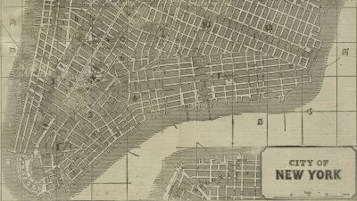
Friday Eye Candy: New York Public Library Releases Thousands of Historic Maps to the Public
“For the historic cartographile, Christmas may have come late, but here it is,” writes Daniel Stuckey.
Mapping Transit "Deserts": An Imperfect Science
The first step to solving the transit “desert” problem is identifying where those deserts are. But that’s easier said than done.
NYC and Tech Community Work Together to Perfect Mapping Data
A partnership between the NYC Department of Information Technology and Telecommunications (DoITT) and OpenStreetMap is a promising example of the public sector and tech communities working together to improve the accuracy and usability of data sets.
With GE Partnership, Google Maps Goes Underground
GE and Google maps have announced a new partnership that could lead to significant advances in the way infrastructure is planned, cataloged, and maintained, reports Michael V. Copeland.
Using Geodesign to Model the Complex Intersection of Land Use and Climate Change
The subject of a recent summit hosted by software maker Esri, Larry Greenemeier explains the application of Geodesign to help predict and manage the increasingly complex intersection of design, land use, ecology, and climate change.
Six Magnificent Maps of 2012
The "best of 2012" lists are just starting to spread and, already, one of the most unique collections we've come across is Caitlin Dempsey's look at the year's most interesting maps. You don't have to be a cartographer to enjoy these visualizations.
Where to Find Elusive GIS-Ready Census Data
For planners searching for hard to find historic census data in a GIS-ready format, the National Historical Geographic Information System (NHGIS) may be the one-stop shop you've been looking for.
Geocoding the Health Impacts of Your Neighborhood
Ever wonder what effect the pollution you're exposed to in your neighborhood on a daily basis is having on your family's long-term health? The emerging field of geo-medecine is providing answers, reports Christine MacDonald.
Land Trust an Unexpected Ally in Indiana's Planning Scene
Ole Amundsen discusses the Central Indiana Land Trust's recent work in proactive land use planning, signaling a broader change in the way land trusts are doing business.
Can the 'Wikipedia of Maps' Challenge Google?
Google starts charging for its maps, and an open source alternative -- with support from Microsoft -- begins to challenge Google's dominance.
GIS Whizzes Get Antarctica on Google Maps
The editor of the Antarctic Sun says that while Antarctica has always been viewable in Google Maps, the imagery was "about as sharp as the graphics in Pong." The folks at the Polar Geospatial Center came to the rescue.
How the U.N. Uses GIS to Manage Humantarian Responses
Two planners with the United Nations Office for the Coordination of Humanitarian Affairs (OCHA) reveal how they use GIS to coordinate their efforts, using the recent tsunami and earthquake in Japan as an example.
Mapping Seattle's Bikeability
Comparing Seattle to Portland, transportation planner Adam Parast used GIS data to show the most bikeable parts of the city.
Using Crowds, and GPS, to Chart Roadkill
Ron Ringen has logged more than 1,400 animals for a roadkill project. "I'm almost a fanatic with it," he said. "You get hooked."
Urban Design for Planners 1: Software Tools
This six-course series explores essential urban design concepts using open source software and equips planners with the tools they need to participate fully in the urban design process.
Planning for Universal Design
Learn the tools for implementing Universal Design in planning regulations.
Smith Gee Studio
City of Charlotte
City of Camden Redevelopment Agency
City of Astoria
Transportation Research & Education Center (TREC) at Portland State University
US High Speed Rail Association
City of Camden Redevelopment Agency
Municipality of Princeton (NJ)


