


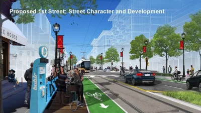
The city of Milwaukee has renderings to illustrate its ambitions for transit oriented development surrounding the streetcar extension into Bronzeville and Walker's Point.

"The City of Milwaukee has released conceptual renderings of how extending the streetcar system to Bronzeville and Walker’s Point could change both neighborhoods," reports Jermey Jannene.
The renderings, released to the public at a recent public hearing, depict streets with a full suite of complete street and traffic calming infrastructure. Jannene summarizes the depictions:
In Walker’s Point, the renderings depict empty lots on a traffic-calmed S. 1st St. being developed into mid-rise buildings and continued activation of S. 2nd St. following the street’s 2010 narrowing. A greenway, a street that encourages cycling over high-speed driving, is proposed for Washington St. that would better connect Walker’s Point and the Harbor District to neighborhoods to the west for cyclists. A similar proposal, sometimes called a bike boulevard, is in the works for Riverwest.
A rendering for Bronzeville depicts N. Martin Luther King Jr. Dr. receiving new development in context with existing buildings on the street. Traffic calming, green-painted bike lanes and medians are all depicted.
Click through to see the full set of renderings and also check out websites for the city's ongoing planning efforts regarding King Drive and the neighborhoods of Bronzeville and Walker's Point as well as the Milwaukee Streetcar.
FULL STORY: Renderings for Streetcar Extensions

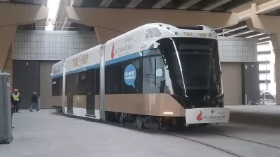
'The Hop' Streetcar Opens to the Public Today in Milwaukee
The Hop will deliver new transit service on the east side of downtown Milwaukee. The Hop comes also serves big development expectations from local officials.
Land Use Planning Precedes Streetcar Extension in Milwaukee
Plans to extend Milwaukee's The Hop streetcar line are still years away from fruition, but the city is already at work on development plans to make the most of the opportunity.

Why Free Rides on the Milwaukee 'Hop' Streetcar Are a Bad Idea
Citing the psychological impact of doughnuts and the American Red Cross, one opinion writer questions the wisdom of a recent sponsorship deal.

Maui's Vacation Rental Debate Turns Ugly
Verbal attacks, misinformation campaigns and fistfights plague a high-stakes debate to convert thousands of vacation rentals into long-term housing.

Planetizen Federal Action Tracker
A weekly monitor of how Trump’s orders and actions are impacting planners and planning in America.

In Urban Planning, AI Prompting Could be the New Design Thinking
Creativity has long been key to great urban design. What if we see AI as our new creative partner?

Cal Fire Chatbot Fails to Answer Basic Questions
An AI chatbot designed to provide information about wildfires can’t answer questions about evacuation orders, among other problems.

What Happens if Trump Kills Section 8?
The Trump admin aims to slash federal rental aid by nearly half and shift distribution to states. Experts warn this could spike homelessness and destabilize communities nationwide.

Sean Duffy Targets Rainbow Crosswalks in Road Safety Efforts
Despite evidence that colorful crosswalks actually improve intersection safety — and the lack of almost any crosswalks at all on the nation’s most dangerous arterial roads — U.S. Transportation Secretary Duffy is calling on states to remove them.
Urban Design for Planners 1: Software Tools
This six-course series explores essential urban design concepts using open source software and equips planners with the tools they need to participate fully in the urban design process.
Planning for Universal Design
Learn the tools for implementing Universal Design in planning regulations.
Appalachian Highlands Housing Partners
Gallatin County Department of Planning & Community Development
Heyer Gruel & Associates PA
Mpact (founded as Rail~Volution)
City of Camden Redevelopment Agency
City of Astoria
City of Portland
City of Laramie