


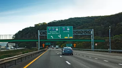
USDOT hopes to put decades of data collection to new use preventing fatal collisions by predicting when they might occur.

Taking a fresh look at its 750 "siloed and unrefined" national datasets, USDOT plans to identify and combat some of the less obvious contributors to fatal crashes—going beyond direct causes, like speeding, to proximate factors like time of day, road conditions, and weather.
As part of the new initiative, USDOT will partner with Waze to compare real-time and historical data on unsafe road conditions in order to gauge the likelihood of future collisions. Eventually, they hope to use artificial intelligence to find more nuanced connections among contributing factors.
Eno Transportation reports that the initiative will begin with two pilot programs:
The first project will help USDOT to better understand how vehicle speed, speed differentials, and roadway characteristics factor into fatal crashes. GPS-enabled devices will collect anonymized data on the prevailing speeds of vehicles across the entire National Highway System every 5 minutes. This will be the first time that USDOT has conducted such a study on a national scale.
The second pilot will leverage roadway hazard reports from Waze users on the road and USDOT’s historical crash data to estimate crash risks ahead of time. This might not only predict the likelihood of a crash, but also could present opportunities to mitigate those risks ahead of time by notifying drivers using the app.
FULL STORY: USDOT Launches New Data Initiative to Predict (and Maybe Prevent) Fatal Crashes


Despite Stay-at-Home Orders, U.S. Traffic Deaths Rose in 2020
Dangerous behaviors picked up during the early, low-traffic days of the pandemic are partly to blame.
Traffic Deaths Rise in New York State, Despite Fewer Crashes
Traffic fatality rates have spiked in New York State since the pandemic, with speeding and drunk driving among the biggest catalysts.

The Geography of Fatal Car Crashes
Where do the most traffic deaths happen?

Planetizen Federal Action Tracker
A weekly monitor of how Trump’s orders and actions are impacting planners and planning in America.

Maui's Vacation Rental Debate Turns Ugly
Verbal attacks, misinformation campaigns and fistfights plague a high-stakes debate to convert thousands of vacation rentals into long-term housing.

Restaurant Patios Were a Pandemic Win — Why Were They so Hard to Keep?
Social distancing requirements and changes in travel patterns prompted cities to pilot new uses for street and sidewalk space. Then it got complicated.

In California Battle of Housing vs. Environment, Housing Just Won
A new state law significantly limits the power of CEQA, an environmental review law that served as a powerful tool for blocking new development.

Boulder Eliminates Parking Minimums Citywide
Officials estimate the cost of building a single underground parking space at up to $100,000.

Orange County, Florida Adopts Largest US “Sprawl Repair” Code
The ‘Orange Code’ seeks to rectify decades of sprawl-inducing, car-oriented development.
Urban Design for Planners 1: Software Tools
This six-course series explores essential urban design concepts using open source software and equips planners with the tools they need to participate fully in the urban design process.
Planning for Universal Design
Learn the tools for implementing Universal Design in planning regulations.
Heyer Gruel & Associates PA
JM Goldson LLC
Custer County Colorado
City of Camden Redevelopment Agency
City of Astoria
Transportation Research & Education Center (TREC) at Portland State University
Jefferson Parish Government
Camden Redevelopment Agency
City of Claremont