


When it's said that most people live in cities, a significant portion of that number are people living in suburbs near cities. A new map shows just how far everyone travels to get to a big city.
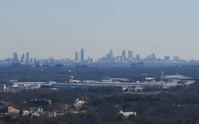
Jessica Stewart shares news of a new mapping project by the University of Oxford's Malaria Atlas Project, published by the journal Nature, by citing the oft-quoted-but-largely-misleading statistic about 50 percent of the world's population living in cities. The study's findings are more nuanced than that lede-friendly nugget: in 2015, 80.7% of all people lived within an hour of a city.
Other findings of the study including insight into the geography of poverty:
In some areas, like sub-Saharan Africa, access to the city is also a large indicator of wealth, with only 50% of people living in low-income areas residing within an hour of the city. This is in stark contrast to people living in high-income areas, as 90.7% of these individuals can reach the city in less than an hour.
The Malaria Atlas Project made its findings public as an interactive online map and data explorer.
FULL STORY: New Map Shows How Long It Takes People Around the World to Travel to the Nearest City


How to Define the Suburban: HUD Survey Sheds New Light
A new HUD survey could help change the way the federal government defines the "suburban"—a notoriously tricky proposition.

Renters Now Outnumber Homeowners in Over 200 US Suburbs
High housing costs in city centers and the new-found flexibility offered by remote work are pushing more renters to suburban areas.

The Natalist Case For Sprawl (And Why It Fails)
Some commentators defend anti-urban government policies such as exclusionary zoning on the basis that homeowning suburbanites have high birth rates. But this doesn't seem to be true in recent decades.

Planetizen Federal Action Tracker
A weekly monitor of how Trump’s orders and actions are impacting planners and planning in America.

Congressman Proposes Bill to Rename DC Metro “Trump Train”
The Make Autorail Great Again Act would withhold federal funding to the system until the Washington Metropolitan Area Transit Authority (WMATA), rebrands as the Washington Metropolitan Authority for Greater Access (WMAGA).

The Simple Legislative Tool Transforming Vacant Downtowns
In California, Michigan and Georgia, an easy win is bringing dollars — and delight — back to city centers.

The States Losing Rural Delivery Rooms at an Alarming Pace
In some states, as few as 9% of rural hospitals still deliver babies. As a result, rising pre-term births, no adequate pre-term care and "harrowing" close calls are a growing reality.

The Small South Asian Republic Going all in on EVs
Thanks to one simple policy change less than five years ago, 65% of new cars in this Himalayan country are now electric.

DC Backpedals on Bike Lane Protection, Swaps Barriers for Paint
Citing aesthetic concerns, the city is removing the concrete barriers and flexposts that once separated Arizona Avenue cyclists from motor vehicles.
Urban Design for Planners 1: Software Tools
This six-course series explores essential urban design concepts using open source software and equips planners with the tools they need to participate fully in the urban design process.
Planning for Universal Design
Learn the tools for implementing Universal Design in planning regulations.
Smith Gee Studio
City of Charlotte
City of Camden Redevelopment Agency
City of Astoria
Transportation Research & Education Center (TREC) at Portland State University
US High Speed Rail Association
City of Camden Redevelopment Agency
Municipality of Princeton (NJ)