


Facing explosive development interest around its Metro station, the small city of Culver on L.A.’s Westside is taking steps to shape its mobility future.
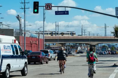
Over the next four years, the five-square-mile city of Culver is expecting ten new developments focused around its Metro Expo Line station to bring 30,000 new daily trips to its streets. In anticipation of those impacts, the Los Angeles-area city has elected to craft, not just a congestion management plan, but a comprehensive vision for mobility and growth that will eventually fold into a general plan update. In The Planning Report, Culver City Vice Mayor Thomas Small and consultant Craig Nelson unpack the Transit Oriented Development Visioning Plan.
Small explains:
Our solution in Culver City is not to try to stop development, but to work with it, and to create a multimodal mobility system that will enable all these people to get around. We need a mobility system that will work with development.
Culver is just one small piece of a patchwork of more than 30 transit networks in Los Angeles County. To create a "complete journey" for riders, the plan will have to find a way to make the transition between infrastructure systems feel seamless.
Creating an easy, comfortable experience is a core component of the plan, which relies heavily on detailed community outreach. That's important in part because transit ridership is falling throughout L.A. County as well as nationwide. Nelson explains:
I’m striving to help transit agencies in the US think beyond a new app, a new website, or new sensors across the network. You need to speak to your users. You need to understand why they don’t use the bus—why it’s uncomfortable for them to use the bus—and think about how good design, good strategy, and good policy can be used to deliver a more accessible and better-to-use transit network.
FULL STORY: Culver City Hosts Mobility Visioning Process Involving Stakeholders, Architects & Planners

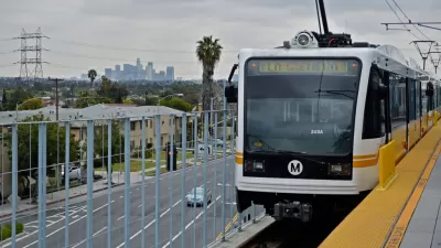
Frequencies Restored on L.A.'s Expo Line After Rider Backlash
Trains were already crowded on the Metro Expo Line when they ran every six minutes during peak hours. When Metro cut frequencies to every eight minutes in June, riders were not pleased.
Proposed New Zoning Around the Los Angeles Expo Line
Los Angeles' proposed transit neighborhood plan for the Expo Line corridor includes minor changes, but nothing earth-shattering. Many of the line's stations remain underutilized.
TOD Grows Hesitantly Around New L.A. Station
L.A.'s newest light-rail station, at the current end-of-the-line off La Cienega, has attracted one new office building so far. The developer saw the future transit station as an amenity. Will others join him?

Planetizen Federal Action Tracker
A weekly monitor of how Trump’s orders and actions are impacting planners and planning in America.

Congressman Proposes Bill to Rename DC Metro “Trump Train”
The Make Autorail Great Again Act would withhold federal funding to the system until the Washington Metropolitan Area Transit Authority (WMATA), rebrands as the Washington Metropolitan Authority for Greater Access (WMAGA).

The Simple Legislative Tool Transforming Vacant Downtowns
In California, Michigan and Georgia, an easy win is bringing dollars — and delight — back to city centers.

The States Losing Rural Delivery Rooms at an Alarming Pace
In some states, as few as 9% of rural hospitals still deliver babies. As a result, rising pre-term births, no adequate pre-term care and "harrowing" close calls are a growing reality.

The Small South Asian Republic Going all in on EVs
Thanks to one simple policy change less than five years ago, 65% of new cars in this Himalayan country are now electric.

DC Backpedals on Bike Lane Protection, Swaps Barriers for Paint
Citing aesthetic concerns, the city is removing the concrete barriers and flexposts that once separated Arizona Avenue cyclists from motor vehicles.
Urban Design for Planners 1: Software Tools
This six-course series explores essential urban design concepts using open source software and equips planners with the tools they need to participate fully in the urban design process.
Planning for Universal Design
Learn the tools for implementing Universal Design in planning regulations.
Smith Gee Studio
City of Charlotte
City of Camden Redevelopment Agency
City of Astoria
Transportation Research & Education Center (TREC) at Portland State University
US High Speed Rail Association
City of Camden Redevelopment Agency
Municipality of Princeton (NJ)