


The ability to predict severe weather events would be a huge benefit to planners, preparing for a new era of resilience. A new study sheds new light on how much rain we can expect, and where, on a warmer planet.
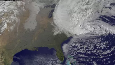
"A new study by researchers from MIT and the Swiss Federal Institute of Technology in Zurich shows that the most extreme rain events in most regions of the world will increase in intensity by 3 to 15 percent, depending on region, for every degree Celsius that the planet warms," reports Jennifer Chu for the MIT News Office.
"If global average temperatures rise by 4 degrees Celsius over the next hundred years, as many climate models predict given relatively high CO2 emissions, much of North America and Europe would experience increases in the intensity of extreme rainfall of roughly 25 percent," adds Chu.
So far, climate modeling has shown extreme weather as a global trend, but the new study begins to reduce the scale of the weather predictions, at the level of continents and even smaller. In doing so, researchers "found that, overall, it was the changes in winds, and not water vapor, that determined the region-to-region variations in the change in extreme rain intensity."
The study was published yesterday in the Nature Climate Change journal.
FULL STORY: Varied increases in extreme rainfall with global warming


Planning Year in Review 2024: An Ongoing Housing Crisis, the Fight for Climate Resilience, and a Mixed Bag for Transportation
A pedestrian safety crisis, rising housing instability, and destructive extreme weather events set the stage for an eventful year.

Key Climate and Health Issues to Watch in 2025
The escalating health impacts of climate change, from extreme heat to sea level rise, highlight the urgent need for integrated medical education, proactive communication, and sustainable policy solutions to protect public health.

Rebuilding America's Backbone: A Call for Resilient Infrastructure
How sustainable investments in infrastructure made today can secure the future.

Planetizen Federal Action Tracker
A weekly monitor of how Trump’s orders and actions are impacting planners and planning in America.

San Francisco's School District Spent $105M To Build Affordable Housing for Teachers — And That's Just the Beginning
SFUSD joins a growing list of school districts using their land holdings to address housing affordability challenges faced by their own employees.

The Tiny, Adorable $7,000 Car Turning Japan Onto EVs
The single seat Mibot charges from a regular plug as quickly as an iPad, and is about half the price of an average EV.

Seattle's Plan for Adopting Driverless Cars
Equity, safety, accessibility and affordability are front of mind as the city prepares for robotaxis and other autonomous vehicles.

As Trump Phases Out FEMA, Is It Time to Flee the Floodplains?
With less federal funding available for disaster relief efforts, the need to relocate at-risk communities is more urgent than ever.

With Protected Lanes, 460% More People Commute by Bike
For those needing more ammo, more data proving what we already knew is here.
Urban Design for Planners 1: Software Tools
This six-course series explores essential urban design concepts using open source software and equips planners with the tools they need to participate fully in the urban design process.
Planning for Universal Design
Learn the tools for implementing Universal Design in planning regulations.
Smith Gee Studio
City of Charlotte
City of Camden Redevelopment Agency
City of Astoria
Transportation Research & Education Center (TREC) at Portland State University
US High Speed Rail Association
City of Camden Redevelopment Agency
Municipality of Princeton (NJ)