


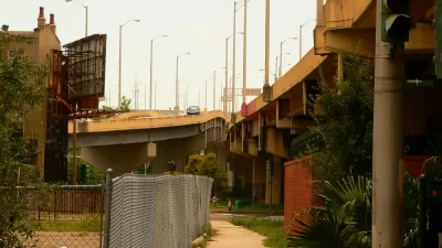
A project to fill-in the Inner Loop in Rochester, New York is underway. It took a lot of contemporary planning to undo this mistake of mid-century planning.

"Realizing the devastating effect urban freeways have had on downtowns across the U.S., many cities are now contemplating some form of freeway removal," according to an article by Norman Garrick. "Most of these discussions haven’t gotten very far, but in Rochester, New York, officials have moved beyond the talking phase and are actually taking action."
Work is already underway in covering over the ditch that once gave cars access to the Inner Loop at the expense of Rochester's neighborhoods.
Garrick relates a history of the planning and political work that preceded the demise of I-490—dating back to the 1990s. "This two-decade long effort culminated in the city finally winning a TIGER grant for over $17 million from the USDOT for the removal of a 2/3-mile long stretch of the Inner Loop," adds Garrick. "The total cost of the project: $22 million."
Garrick (who was one of the researchers behind a study that made news earlier this year for finding the strongest evidence yet "that parking is a 'likely cause' of increased driving") also provides a few lessons in overthrowing the 20th century paradigms that put cars first.
FULL STORY: Burying a 1950s Planning Disaster

Ten 'Freeways Without Futures'
The Congress for New Urbanism has once again released on if its signature efforts: the Freeways Without Futures report that assumes urban freeways were a mistake of 20th century planning and engineering and advocates for a new approach.
Economic Justice Includes Highway Removals
A $435 billion "economic justice" bill proposed by Democrats in the U.S. Senate includes $10 billion for projects that remove highways and build community-oriented assets in their place.
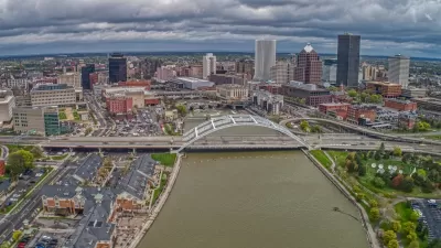
Rochester Shows Possible Future for Former Highways
A former freeway is undergoing a massive redevelopment that goes beyond highway removal to reconnect and revitalize surrounding areas.

Planetizen Federal Action Tracker
A weekly monitor of how Trump’s orders and actions are impacting planners and planning in America.

Restaurant Patios Were a Pandemic Win — Why Were They so Hard to Keep?
Social distancing requirements and changes in travel patterns prompted cities to pilot new uses for street and sidewalk space. Then it got complicated.

Map: Where Senate Republicans Want to Sell Your Public Lands
For public land advocates, the Senate Republicans’ proposal to sell millions of acres of public land in the West is “the biggest fight of their careers.”

Maui's Vacation Rental Debate Turns Ugly
Verbal attacks, misinformation campaigns and fistfights plague a high-stakes debate to convert thousands of vacation rentals into long-term housing.

San Francisco Suspends Traffic Calming Amidst Record Deaths
Citing “a challenging fiscal landscape,” the city will cease the program on the heels of 42 traffic deaths, including 24 pedestrians.

California Homeless Arrests, Citations Spike After Ruling
An investigation reveals that anti-homeless actions increased up to 500% after Grants Pass v. Johnson — even in cities claiming no policy change.
Urban Design for Planners 1: Software Tools
This six-course series explores essential urban design concepts using open source software and equips planners with the tools they need to participate fully in the urban design process.
Planning for Universal Design
Learn the tools for implementing Universal Design in planning regulations.
Heyer Gruel & Associates PA
JM Goldson LLC
Custer County Colorado
City of Camden Redevelopment Agency
City of Astoria
Transportation Research & Education Center (TREC) at Portland State University
Camden Redevelopment Agency
City of Claremont
Municipality of Princeton (NJ)