


Some local residents of the Faroe Islands created Sheep View 360 to document the 18 rocky islands that make up their home—and now Google is lending a hand.

"Those zany madcaps over at Google have been having WAY too much fun lately," according to an article by Patrick May. "The kind you have when you get to strap Google’s high-tech street-view cameras to some of the 70,000 sheep wandering around the Faroe Islands, a self-governing archipelago that’s part of the Kingdom of Denmark."
This whole story began with Sheep View 360. According to an article from July, a local shepherd built custom harnesses to fit five sheep living on the Faroe Islands with a 36-degree camera. The effort was a preemptive effort to map the islands. Google Street View hadn't made brought its mapping project to the Faroe Islands yet, given their remote location and difficult conditions.
But after hearing about Sheep View 360, Google decided to loan the team cameras through the Street View camera loan program, which also happens to be available in places other than the Faroe Islands.
Meanwhile, there's also this video to illustrate more about how the project and partnership all came together.
FULL STORY: Ever see Googlers in sheep’s clothing?

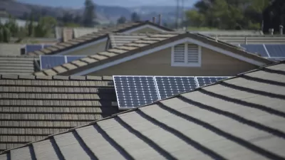
Mapping Rooftop Solar to Make It a Social Norm
Debuted in 2015, Google's Project Sunroof is designed make it easier for homeowners to go solar. Now the tool is harnessing peer pressure to "create a social norm" around solar.
Google Debuts Rooftop Solar Mapping Tool
Currently in its early stages, Project Sunroof tracks how much sun every roof receives. Then it estimates the costs and savings if rooftop solar were installed. Right now, the tool only covers the Bay Area, Fresno, and Boston.
Britain's WiFi Networks Mapped
Search giant Google has mapped the location of every WiFi network in Britain. Some say the collection of this information is a violation of privacy.

Planetizen Federal Action Tracker
A weekly monitor of how Trump’s orders and actions are impacting planners and planning in America.

Map: Where Senate Republicans Want to Sell Your Public Lands
For public land advocates, the Senate Republicans’ proposal to sell millions of acres of public land in the West is “the biggest fight of their careers.”

Restaurant Patios Were a Pandemic Win — Why Were They so Hard to Keep?
Social distancing requirements and changes in travel patterns prompted cities to pilot new uses for street and sidewalk space. Then it got complicated.

Maui's Vacation Rental Debate Turns Ugly
Verbal attacks, misinformation campaigns and fistfights plague a high-stakes debate to convert thousands of vacation rentals into long-term housing.

San Francisco Suspends Traffic Calming Amidst Record Deaths
Citing “a challenging fiscal landscape,” the city will cease the program on the heels of 42 traffic deaths, including 24 pedestrians.

California Homeless Arrests, Citations Spike After Ruling
An investigation reveals that anti-homeless actions increased up to 500% after Grants Pass v. Johnson — even in cities claiming no policy change.
Urban Design for Planners 1: Software Tools
This six-course series explores essential urban design concepts using open source software and equips planners with the tools they need to participate fully in the urban design process.
Planning for Universal Design
Learn the tools for implementing Universal Design in planning regulations.
Heyer Gruel & Associates PA
JM Goldson LLC
Custer County Colorado
City of Camden Redevelopment Agency
City of Astoria
Transportation Research & Education Center (TREC) at Portland State University
Camden Redevelopment Agency
City of Claremont
Municipality of Princeton (NJ)