


The proposed East-West Bus Rapid Transit project has already built the political support that doomed a previous attempt at light rail along the corridor.
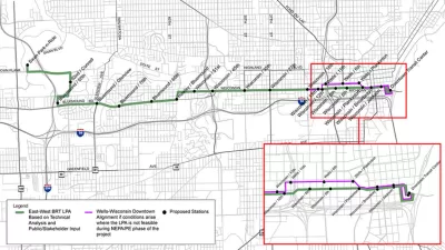
Bruce Murphy reports on a proposed bus rapid transit line in Milwaukee, on the "heavily trafficked, east-west corridor from downtown Milwaukee to Wauwatosa, parallel to I-94." According to Murphy, former Milwaukee Mayor John Norquist proposed a light rail line along the corridor, "but Waukesha County politicians adamantly and successfully opposed it."
"Now we have a proposal to create an nine-mile BRT or Bus Rapid Transit line," reports Murphy, "championed by Milwaukee County Executive Chris Abele, and the response is radically different, suggesting this proposal could succeed."
The article offers an introduction to the concept of Bus Rapid Transit, assuming there are readers in the Milwaukee area who might not be familiar with the quickly growing transit mode. Murphy also points to a model for the proposed Milwaukee line: the 7.1-mile Healthline in Cleveland, which opened in 2008 and "has generated $6.3 billion in new development along the line, including 7,200 housing units," according to Murphy.
The Milwaukee County Transit System has already completed a study of the proposed BRT route, plotting a potential 19 stops, daytime headways of ten minutes, and an estimated price tag of $42 million to $48 million.
FULL STORY: Does Anyone Oppose Bus Rapid Transit?

What to Know About Milwaukee's Proposed East-West Bus Rapid Transit Project
Ambitious hopes ride on a proposed bus rapid transit route connecting Downtown Milwaukee with the Milwaukee Regional Medical Center in Wauwatosa.
Postponed Milwaukee BRT Project at Least a Decade Away
The county’s transit system won’t pursue a second rapid bus line due to financial constraints.
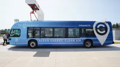
Milwaukee BRT Proves Popular With Riders
The newly opened line is already reaching pre-pandemic ridership levels.

Planetizen Federal Action Tracker
A weekly monitor of how Trump’s orders and actions are impacting planners and planning in America.

Congressman Proposes Bill to Rename DC Metro “Trump Train”
The Make Autorail Great Again Act would withhold federal funding to the system until the Washington Metropolitan Area Transit Authority (WMATA), rebrands as the Washington Metropolitan Authority for Greater Access (WMAGA).

DARTSpace Platform Streamlines Dallas TOD Application Process
The Dallas transit agency hopes a shorter permitting timeline will boost transit-oriented development around rail stations.

Renters Now Outnumber Homeowners in Over 200 US Suburbs
High housing costs in city centers and the new-found flexibility offered by remote work are pushing more renters to suburban areas.

The Tiny, Adorable $7,000 Car Turning Japan Onto EVs
The single seat Mibot charges from a regular plug as quickly as an iPad, and is about half the price of an average EV.

Supreme Court Ruling in Pipeline Case Guts Federal Environmental Law
The decision limits the scope of a federal law that mandates extensive environmental impact reviews of energy, infrastructure, and transportation projects.
Urban Design for Planners 1: Software Tools
This six-course series explores essential urban design concepts using open source software and equips planners with the tools they need to participate fully in the urban design process.
Planning for Universal Design
Learn the tools for implementing Universal Design in planning regulations.
Municipality of Princeton
Roanoke Valley-Alleghany Regional Commission
City of Mt Shasta
City of Camden Redevelopment Agency
City of Astoria
Transportation Research & Education Center (TREC) at Portland State University
US High Speed Rail Association
City of Camden Redevelopment Agency
Municipality of Princeton (NJ)