


Ambitious hopes ride on a proposed bus rapid transit route connecting Downtown Milwaukee with the Milwaukee Regional Medical Center in Wauwatosa.
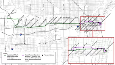
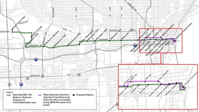
Edgar Mendez reports that Milwaukee County Transit System (MCTS) planners are seeking feedback from the public on the East-West Bus Rapid Transit project, a proposed nine-mile BRT route connecting Downtown Milwaukee to the Milwaukee Regional Medical Center with 75-person-capacity buses every 10 minutes.
Mendez focuses on the expected costs and outcomes of the project. The system is expected to operate at an annual cost of $3.7 million every year, with some funding made available by reducing duplicated service along Wisconsin Avenue. The development of the BRT route is expected to cost $42 million to $48 million, with 80 percent of funding coming from the Federal Transit Administration's Capital Investment Grant program.
The article cites an MCTS spokesperson to list the expected benefits of the project, including increased ridership, decreased driving, congestion relief, and incentives for economic development.
Planetizen checked-in with this project twice in 2016, finding little initial public resistance to the idea (compared to a failed light rail proposal for a similar route) after public outreach officially began for the panning process in March of that year.
FULL STORY: Impact of Bus Rapid Transit in Milwaukee

East-West BRT Proposal Finding Little Resistance in Milwaukee
The proposed East-West Bus Rapid Transit project has already built the political support that doomed a previous attempt at light rail along the corridor.
Postponed Milwaukee BRT Project at Least a Decade Away
The county’s transit system won’t pursue a second rapid bus line due to financial constraints.
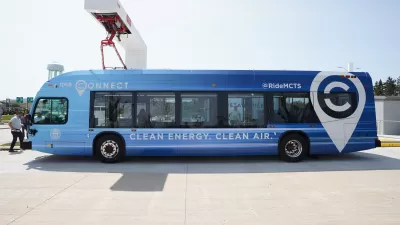
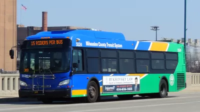
Milwaukee BRT Proves Popular With Riders
The newly opened line is already reaching pre-pandemic ridership levels.

Planetizen Federal Action Tracker
A weekly monitor of how Trump’s orders and actions are impacting planners and planning in America.

Congressman Proposes Bill to Rename DC Metro “Trump Train”
The Make Autorail Great Again Act would withhold federal funding to the system until the Washington Metropolitan Area Transit Authority (WMATA), rebrands as the Washington Metropolitan Authority for Greater Access (WMAGA).

The Simple Legislative Tool Transforming Vacant Downtowns
In California, Michigan and Georgia, an easy win is bringing dollars — and delight — back to city centers.

The States Losing Rural Delivery Rooms at an Alarming Pace
In some states, as few as 9% of rural hospitals still deliver babies. As a result, rising pre-term births, no adequate pre-term care and "harrowing" close calls are a growing reality.

The Small South Asian Republic Going all in on EVs
Thanks to one simple policy change less than five years ago, 65% of new cars in this Himalayan country are now electric.

DC Backpedals on Bike Lane Protection, Swaps Barriers for Paint
Citing aesthetic concerns, the city is removing the concrete barriers and flexposts that once separated Arizona Avenue cyclists from motor vehicles.
Urban Design for Planners 1: Software Tools
This six-course series explores essential urban design concepts using open source software and equips planners with the tools they need to participate fully in the urban design process.
Planning for Universal Design
Learn the tools for implementing Universal Design in planning regulations.
Smith Gee Studio
City of Charlotte
City of Camden Redevelopment Agency
City of Astoria
Transportation Research & Education Center (TREC) at Portland State University
US High Speed Rail Association
City of Camden Redevelopment Agency
Municipality of Princeton (NJ)