Mayor Bill de Blasio is expected to announce ambitious plans for a 16-mile, $2.2 billion streetcar route to connect some of the city's up and coming, but still transit-light, neighborhoods.


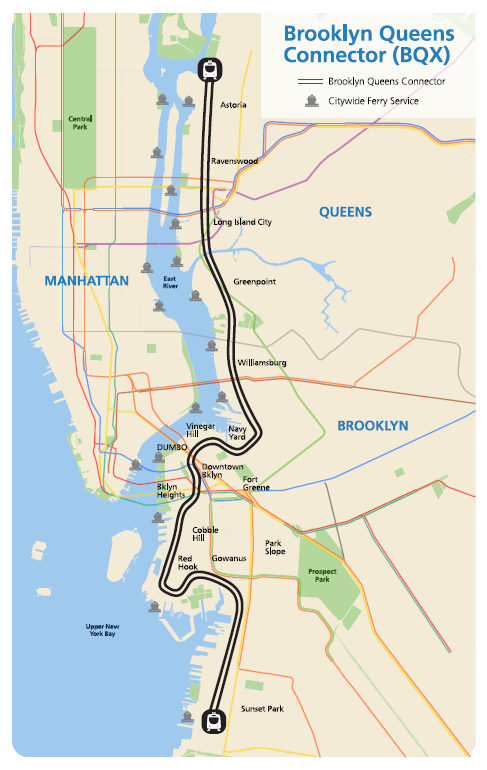
"In a major reimagining of the New York City waterfront, Mayor Bill de Blasio is set to propose a streetcar line that would snake along the East River in Brooklyn and Queens, linking the industrial centers of Sunset Park to the upper reaches of Astoria," reports Michael M. Grynbaum.
Mayor de Blasio's streetcar plan calls for a 16-mile rail line, "that runs on rails embedded in public roadways and flows alongside automobile traffic," according to Grynbaum.
The expected cost of the system is $2.2 billion, and "[a]dministration officials believe the cost can be offset by a revenue stream taken from the expected rise in property values along the route." As Grynbaum notes, the neighborhoods along the route, like Greenpoint and Brooklyn Navy Yard, have already undergone rapid development.
The article also credits the proposal to the "long-held fantasy of the city's urban planners…" The proposed map for the so-called Brooklyn Queens Connector can be seen below.
Read the full story: Mayor de Blasio to Propose Streetcar Line Linking Brooklyn and Queens

Brooklyn-Queens Connector Streetcar Plans Released
Plans for the Brooklyn-Queens Connector, otherwise known as the BQX, are still on the table, despite reports of the project's demise.
MIA or DOA? The Brooklyn-Queens Streetcar Fading Fast
The lack of news on the proposed Brooklyn Queens Connector (BQX) is hardly a death knell, but that doesn't mean no news is good news, either.
Op-Ed: Brooklyn-to-Queens Streetcar Won't Pay for Itself
Who thinks the Brooklyn-to-Queens (BQX) would pay for itself? Someone whose paycheck depends on it, Neil deMause argues.

Planetizen Federal Action Tracker
A weekly monitor of how Trump’s orders and actions are impacting planners and planning in America.

California plans to bury El Niño’s downpour
If the state plays its cards right, it may be able to store a billion acre-feet of El Niño’s water in aquifers.

Chicago breaks ground on $3 billion megadevelopment
The new neighborhood, titled Foundry Park, will one day host 3,700 residences.

California High-Speed Rail Authority CEO resigns after $600,000 scandal
Under Ian Choudri, the authority used taxpayer dollars to fund first class flights and trips to nightclubs.

Want to study the Missouri River? Soon, you may need unanimous approval from 10 states
Legislation would require 10 governors’ permission to study or build projects moving water outside the basin.

Desperate measures: Advocates weigh draining Lake Powell to fill Colorado River
Draining the reservoir could reduce evaporation losses by a couple hundred thousand acre-feet.

FREE Course: Walkable City 1: Why Walkability?
After describing his path towards focusing on walkability as the essence of good planning, Jeff Speck marches through his five principal reasons for making more walkable places.
Reinventing Malls: Planning Alchemy—Turning Gray Fields Into Gold
The course focuses on the opportunities and imperatives that shape reinvention of mall sites.

City of Rosemead
Rutgers University, Edward J. Bloustein School of Planning and Public Policy
One Hundred Miles
Hunter College, City University of New York (CUNY)
The Architects Foundation
University of Cincinnati Online
City of Cambridge
Montrose County
The Pocatello Development Authority