


Aaron Renn scours the Internet to find 12 maps that attempt to do the impossible: define the geographic and cultural expanse known as the American Midwest.
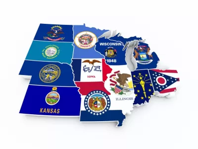
A listicle by Aaron Renn surveys the many different approaches to mapping the Midwest.
The list includes a traditional map, as defined in the early days of the United States, to the bureaucratic definition set forth but the U.S. Census Bureau. Other maps locate the Midwest in relation to the other "nations" in the United States and some break down the larger area of the Midwest into smaller sub-regions, such as the "Lower Lakes," the "North Woods," and the "Plains." Showing off the capabilities of the Internet, online survey mechanisms and the crowdsourcing power of Reddit have also helped a few intrepid social commentators create their own maps. Finally, other data collection methods have helped compile patterns out of the self-selecting behavior of Midwesterners.
FULL STORY: 12 Ways to Map the Midwest


Interactive Map Reveals America's “Shade Deserts”
Launched by UCLA and American Forests to combat heat-related deaths, the tool maps the shade infrastructure for over 360 U.S. cities.

Detroit and Michigan on the Upswing
It's been 66 years since the Motor City last grew its population. Census data released last month revealed an increase of nearly 2,000 people last year, nearly half the state's population growth.

The 15 Fastest-Growing Cities in the US
The U.S. Census Bureau released new 2023 population estimates on May 16 showing a slew of data for cities of all sizes and regions. Do you know the population change last year for the 15 largest cities in your state?

Planetizen Federal Action Tracker
A weekly monitor of how Trump’s orders and actions are impacting planners and planning in America.

Maui's Vacation Rental Debate Turns Ugly
Verbal attacks, misinformation campaigns and fistfights plague a high-stakes debate to convert thousands of vacation rentals into long-term housing.

San Francisco Suspends Traffic Calming Amidst Record Deaths
Citing “a challenging fiscal landscape,” the city will cease the program on the heels of 42 traffic deaths, including 24 pedestrians.

Amtrak Rolls Out New Orleans to Alabama “Mardi Gras” Train
The new service will operate morning and evening departures between Mobile and New Orleans.

The Subversive Car-Free Guide to Trump's Great American Road Trip
Car-free ways to access Chicagoland’s best tourist attractions.

San Antonio and Austin are Fusing Into one Massive Megaregion
The region spanning the two central Texas cities is growing fast, posing challenges for local infrastructure and water supplies.
Urban Design for Planners 1: Software Tools
This six-course series explores essential urban design concepts using open source software and equips planners with the tools they need to participate fully in the urban design process.
Planning for Universal Design
Learn the tools for implementing Universal Design in planning regulations.
Heyer Gruel & Associates PA
JM Goldson LLC
Custer County Colorado
City of Camden Redevelopment Agency
City of Astoria
Transportation Research & Education Center (TREC) at Portland State University
Jefferson Parish Government
Camden Redevelopment Agency
City of Claremont