


A new resource created by the National Oceanic and Atmospheric Administration in partnership with the APA makes it easier for planners to access the data necessary to plan for climate adaptation, sea level rise, and other forms of coastal resilience.
The National Oceanic and Atmospheric Administration has created a resource called Digital Coast, which "hosts freely available data on coastal hazards, along with a lot of site-specific local data, as well as the training, tools, and resources needed to turn these data into useful information," according to a post on the APA Policy News blog.
"Developed by NOAA’s Office for Coastal Management, with support from partnership organizations such as the APA, the Digital Coast is an enabling platform that assists users in analyzing coastal vulnerability, simulating projections of impacts, creating publishable visualizations and “snapshots” of potential future scenarios, and more. Digital Coast tools and data that are directly focused on climate adaptation and hazard planning include the Sea Level Rise Viewer, the Coastal Flood Exposure Mapper, and high resolution elevation datasets (derived from Light Detection and Ranging, or LiDAR)."
The article includes more insight into the resources provided by Digital Coast and other partnerships with NOAA and APA divisions.
FULL STORY: Digital Coast Helps Planners Build Hazard Resilient Communities


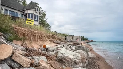
Connecticut Shoreline Rail Vulnerable to Floods
Long stretches of Connecticut's "lifeblood" shoreline rail line lie in the path of rising seas and future floods. While moving the tracks further inland is prohibitively expensive, a resilience plan is still needed.
How US Cities Can Prepare for Climate Disasters
Resilience, encompassing infrastructure, governance, economic strength, and social cohesion, is critical for cities to mitigate rising climate risks like flooding, wildfires, and heat, ensuring long-term recovery and adaptability.

NOAA Awards $575M in Coastal Resilience Grants
The program received over $16 billion in requests from communities around the country.

Planetizen Federal Action Tracker
A weekly monitor of how Trump’s orders and actions are impacting planners and planning in America.

Map: Where Senate Republicans Want to Sell Your Public Lands
For public land advocates, the Senate Republicans’ proposal to sell millions of acres of public land in the West is “the biggest fight of their careers.”

Restaurant Patios Were a Pandemic Win — Why Were They so Hard to Keep?
Social distancing requirements and changes in travel patterns prompted cities to pilot new uses for street and sidewalk space. Then it got complicated.

Albuquerque Route 66 Motels Become Affordable Housing
A $4 million city fund is incentivizing developers to breathe new life into derelict midcentury motels.

DC Area County Eliminates Bus Fares
Montgomery County joins a growing trend of making transit free.

Platform Pilsner: Vancouver Transit Agency Releases... a Beer?
TransLink will receive a portion of every sale of the four-pack.
Urban Design for Planners 1: Software Tools
This six-course series explores essential urban design concepts using open source software and equips planners with the tools they need to participate fully in the urban design process.
Planning for Universal Design
Learn the tools for implementing Universal Design in planning regulations.
Heyer Gruel & Associates PA
JM Goldson LLC
Custer County Colorado
City of Camden Redevelopment Agency
City of Astoria
Transportation Research & Education Center (TREC) at Portland State University
Camden Redevelopment Agency
City of Claremont
Municipality of Princeton (NJ)