


Long stretches of Connecticut's "lifeblood" shoreline rail line lie in the path of rising seas and future floods. While moving the tracks further inland is prohibitively expensive, a resilience plan is still needed.
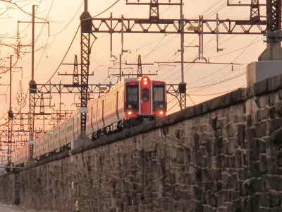
In the first of two articles on a vulnerable stretch of rail, Jan Ellen Spiegel discusses Connecticut's difficult path toward climate change resilience. "When storm Sandy hit in October 2012, the tracks in Bridgeport stayed dry, but the storm surge still flowed out to the street — appropriately Water Street — leaving the train station an island with its entrances inaccessible and part of the embankment under the tracks washed away."
More storms are yet to come, potentially submerging sections of track altogether. "The prospect has some worrying that the state plan to spend billions fixing long-standing safety and reliability problems and upgrading the line to encourage ridership will entrench the system in locations that may not be the best environmental choices."
In addition to dense development around the tracks, these projects ensure that the line will not, in all likelihood, be moved further inland.
Regional planners and the train operators have instead focused on resilience, in the knowledge that cleaning up after floods will be easier than building a system immune to them. "The MTA's Dutta said flexibility is a key component of recovery, which can include suspending service. It can also include moving equipment such as trains, ground-level switches and all manner of electrical components that are especially susceptible to salt-water damage."
FULL STORY: Climate Change Threatens Connecticut's Vital Shoreline Rail


How US Cities Can Prepare for Climate Disasters
Resilience, encompassing infrastructure, governance, economic strength, and social cohesion, is critical for cities to mitigate rising climate risks like flooding, wildfires, and heat, ensuring long-term recovery and adaptability.
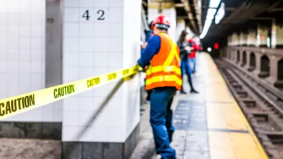
Why New York City's Flooding Its Own Subway Entrances
MTA reassured disoriented New Yorkers that it's flooding subway entrances on purpose, to test barriers that it hopes will guard the system against another Sandy.

FEMA Resilience Program Cuts Grant Funding
The Building Resilient Infrastructure and Communities program funded projects from flood prevention to power station upgrades.

Planetizen Federal Action Tracker
A weekly monitor of how Trump’s orders and actions are impacting planners and planning in America.

Congressman Proposes Bill to Rename DC Metro “Trump Train”
The Make Autorail Great Again Act would withhold federal funding to the system until the Washington Metropolitan Area Transit Authority (WMATA), rebrands as the Washington Metropolitan Authority for Greater Access (WMAGA).

DARTSpace Platform Streamlines Dallas TOD Application Process
The Dallas transit agency hopes a shorter permitting timeline will boost transit-oriented development around rail stations.

LA County Creating Action Plan to Tackle Extreme Heat
Los Angeles County is creating a Heat Action Plan to help communities stay safe during extreme heat, with steps like adding more shade, improving buildings, and supporting the neighborhoods most at risk.

Maryland Plans Quick-Build Complete Streets Projects
The state will use low-cost interventions to improve road safety in five Maryland counties.

Downtown Los Angeles Gears Up for Growth
A new report highlights Downtown L.A.’s ongoing revival through major housing projects, adaptive reuse, hospitality growth, and preparations for global events in the years ahead.
Urban Design for Planners 1: Software Tools
This six-course series explores essential urban design concepts using open source software and equips planners with the tools they need to participate fully in the urban design process.
Planning for Universal Design
Learn the tools for implementing Universal Design in planning regulations.
City of Charlotte
Municipality of Princeton
Roanoke Valley-Alleghany Regional Commission
City of Camden Redevelopment Agency
City of Astoria
Transportation Research & Education Center (TREC) at Portland State University
US High Speed Rail Association
City of Camden Redevelopment Agency
Municipality of Princeton (NJ)