


Roundabouts, not to be confused with traffic circles, are becoming popular throughout the United States. The Bronx will get the first one in NYC. The insurance industry and FHWA consider them far safer than traffic lights and stop signs.
"Once seen only in countries like France and Britain, the roundabout, favored by traffic engineers because it cuts congestion and reduces collisions and deaths, is experiencing rapid growth in the United States," writes technology reporter Eric Taub. New York State has gone from 18 in 2005 to 112 today.
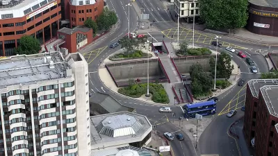
And New York City is getting its first one this month, when a three-way intersection in the Bronx that has been a challenge for pedestrians completes its conversion.
Before: Intervale Avenue at Dawson Street was an asphalt expanse where crossing distances are up to 200 feet. Photo: DOT [PDF] via Streetsblog NYC.

"The proposal is part of a larger road diet for Intervale Avenue in Longwood [PDF]," wrote Stephen Miller for Streetsblog NYC in February. "The plan was supported by a Bronx Community Board 2 committee in a 7-1 vote earlier this month."
The plan would convert Dawson Street from one-way to two-way and add “splitter islands” to both divide traffic as it approaches the roundabout and give refuge to pedestrians.
"Compared with stop signs and traffic lights, roundabouts are significantly safer, engineers say," writes Taub. "For example, crashes that result in serious injuries or death are reduced by 82 percent versus a two-way stop, and by 78 percent compared with an intersection with traffic lights, according to Jeff Shaw, the intersections program manager for the Federal Highway Administration."
According to Richard Retting, a former transportation researcher at the Insurance Institute for Highway Safety, "the reduction in injuries and fatalities was 'unmatched by anything else we can do in traffic engineering.'”
FULL STORY: As Americans Figure Out the Roundabout, It Spreads Across the U.S.

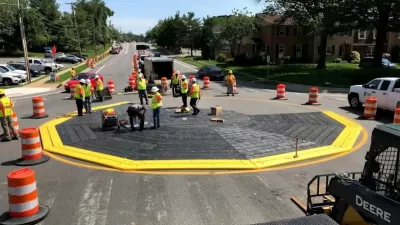
‘Modular Roundabouts’ Offer Quick-Build Traffic Safety Solution
The prefabricated roundabouts can be installed more quickly and at a much lower cost than traditional concrete traffic circles.
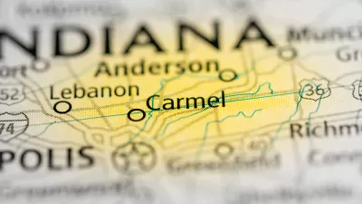
Bike-Friendly City in Indiana is Known for Plentiful Roundabouts
Indiana's fifth-largest city, of just under 100,000, residents has 120 roundabouts, more than any city in the U.S., and only 14 traffic lights. The average traffic fatality rate is 83 percent lower than the national average.

Red Light Cameras Receive Endorsement from Influential Governors' Group
Calling it 'mind boggling' that municipalities are removing 'proven safety tools,' the Governors Highway Safety Association strongly endorsed the use of the controversial red light cameras to 'to improve safety for all road users.'

Planetizen Federal Action Tracker
A weekly monitor of how Trump’s orders and actions are impacting planners and planning in America.

Map: Where Senate Republicans Want to Sell Your Public Lands
For public land advocates, the Senate Republicans’ proposal to sell millions of acres of public land in the West is “the biggest fight of their careers.”

Restaurant Patios Were a Pandemic Win — Why Were They so Hard to Keep?
Social distancing requirements and changes in travel patterns prompted cities to pilot new uses for street and sidewalk space. Then it got complicated.

Platform Pilsner: Vancouver Transit Agency Releases... a Beer?
TransLink will receive a portion of every sale of the four-pack.

Toronto Weighs Cheaper Transit, Parking Hikes for Major Events
Special event rates would take effect during large festivals, sports games and concerts to ‘discourage driving, manage congestion and free up space for transit.”

Berlin to Consider Car-Free Zone Larger Than Manhattan
The area bound by the 22-mile Ringbahn would still allow 12 uses of a private automobile per year per person, and several other exemptions.
Urban Design for Planners 1: Software Tools
This six-course series explores essential urban design concepts using open source software and equips planners with the tools they need to participate fully in the urban design process.
Planning for Universal Design
Learn the tools for implementing Universal Design in planning regulations.
Heyer Gruel & Associates PA
JM Goldson LLC
Custer County Colorado
City of Camden Redevelopment Agency
City of Astoria
Transportation Research & Education Center (TREC) at Portland State University
Camden Redevelopment Agency
City of Claremont
Municipality of Princeton (NJ)