


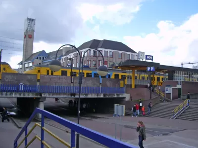
Well-known in transportation planning circles, Houten's suburban multi-modality can be found almost nowhere else. Perimeter ring roads, train access, and bike-friendly features have cut car trips down to 44 percent.
First developed in the 1980s, Houten and adjacent town South Houten now house 50,000 residents. But with 66 percent of trips made by alternate modes, Houten isn't your typical suburb.
Eric Jaffe describes how Houten's layout restricts automobile movement: "Car traffic is primarily resigned to a 'ring road' that encircles the area. Within that ring is a network of low-speed streets meant primarily for people traveling on foot or by bike (there are 80 miles of bicycle paths alone) that connect to two main intercity train stations and most of the area's schools and shops."
If they commute to other areas by car, arriving drivers "exit the ring roads onto local streets in the core of Houten that extend into individual neighborhoods but don't connect to other parts of town. To get somewhere else by car, you have to get back on the ring road."
Other multi-modal planning features include comprehensive access to commuter rail, 18-mph speed limits, and streets reserved for walkers and cyclists. "The bike paths in the extensive cycling network have their own brick red coloring. Where bike routes do cross the ring roads, underpasses separate bike and car traffic."
It's doubtful whether the Houten model could work in the USA. To one American planner, Houten betrays a "Truman Show" artificiality: "Here you find a balanced transport system but little else." To be fair, longtime Houten residents probably feel differently about their home.
FULL STORY: A Case Study in Bike-Friendly Suburban Planning

Indy Neighborhood Group Builds Temporary Multi-Use Path
Community members, aided in part by funding from the city, repurposed a vehicle lane to create a protected bike and pedestrian path for the summer season.

Understanding Road Diets
An explainer from Momentum highlights the advantages of reducing vehicle lanes in favor of more bike, transit, and pedestrian infrastructure.

Houston Residents Respond to Mobility Questions
What could the city look like if budget and bureaucracy were no object?

Maui's Vacation Rental Debate Turns Ugly
Verbal attacks, misinformation campaigns and fistfights plague a high-stakes debate to convert thousands of vacation rentals into long-term housing.

Planetizen Federal Action Tracker
A weekly monitor of how Trump’s orders and actions are impacting planners and planning in America.

In Urban Planning, AI Prompting Could be the New Design Thinking
Creativity has long been key to great urban design. What if we see AI as our new creative partner?

King County Supportive Housing Program Offers Hope for Unhoused Residents
The county is taking a ‘Housing First’ approach that prioritizes getting people into housing, then offering wraparound supportive services.

Researchers Use AI to Get Clearer Picture of US Housing
Analysts are using artificial intelligence to supercharge their research by allowing them to comb through data faster. Though these AI tools can be error prone, they save time and housing researchers are optimistic about the future.

Making Shared Micromobility More Inclusive
Cities and shared mobility system operators can do more to include people with disabilities in planning and operations, per a new report.
Urban Design for Planners 1: Software Tools
This six-course series explores essential urban design concepts using open source software and equips planners with the tools they need to participate fully in the urban design process.
Planning for Universal Design
Learn the tools for implementing Universal Design in planning regulations.
planning NEXT
Appalachian Highlands Housing Partners
Mpact (founded as Rail~Volution)
City of Camden Redevelopment Agency
City of Astoria
City of Portland
City of Laramie