


When water policy and land use planning operate in separate spheres, it's more difficult to design for efficient resource use. Better communication is needed in the drought-stricken southwest.

In this piece for Next City, Rachel Dovey explains why land use planners and water district officials "don't speak the same language" when it comes to designating resources efficiently. The first culprit is sprawl itself: "Lawns for single-family homes; paved-over green space along an expanding border; parking lots that funnel storm water into disposal drains [...] and a subterranean network of mains and pipes that becomes costlier as its footprint grows."
Lack of coordination between the two types of planning also takes its toll: "For example, water agencies often project a city's future consumption based on current gallon-per-household-per-month figures. But if planners are up-zoning a city for mixed-use, thereby cutting water demand, everyone ends up with inflated data."
The southwestern regions hit hardest by the current drought "also happen to be the regions that built cities for cars, garages, lawns and single-family homes." The article cites an expert who believes that most officials understand the need for infill, but smart growth and actual water savings don't always go hand-in-hand.
FULL STORY: Why Planners and Water Officials Need to Hang Out


Californians Struggle To Cut Water Use
The state is slowly starting to curb water consumption, but progress has been ‘disappointingly slow’ as water supplies across the West diminish to historic lows.

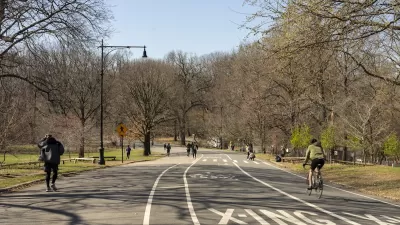
NYC Under Drought Warning, Residents Urged to Conserve Water
Amid a series of brush fires, including one in Manhattan, the city issued the first drought warning in 22 years and announced plans to release water through the Delaware Aqueduct to supplement local reservoirs.
New Yorkers Face New Climate Risks
A two-acre fire in a city park prompted city officials to ban grilling while urging residents to conserve water to limit the impact of a historic drought.

Planetizen Federal Action Tracker
A weekly monitor of how Trump’s orders and actions are impacting planners and planning in America.

Restaurant Patios Were a Pandemic Win — Why Were They so Hard to Keep?
Social distancing requirements and changes in travel patterns prompted cities to pilot new uses for street and sidewalk space. Then it got complicated.

Map: Where Senate Republicans Want to Sell Your Public Lands
For public land advocates, the Senate Republicans’ proposal to sell millions of acres of public land in the West is “the biggest fight of their careers.”

Maui's Vacation Rental Debate Turns Ugly
Verbal attacks, misinformation campaigns and fistfights plague a high-stakes debate to convert thousands of vacation rentals into long-term housing.

San Francisco Suspends Traffic Calming Amidst Record Deaths
Citing “a challenging fiscal landscape,” the city will cease the program on the heels of 42 traffic deaths, including 24 pedestrians.

California Homeless Arrests, Citations Spike After Ruling
An investigation reveals that anti-homeless actions increased up to 500% after Grants Pass v. Johnson — even in cities claiming no policy change.
Urban Design for Planners 1: Software Tools
This six-course series explores essential urban design concepts using open source software and equips planners with the tools they need to participate fully in the urban design process.
Planning for Universal Design
Learn the tools for implementing Universal Design in planning regulations.
Heyer Gruel & Associates PA
JM Goldson LLC
Custer County Colorado
City of Camden Redevelopment Agency
City of Astoria
Transportation Research & Education Center (TREC) at Portland State University
Camden Redevelopment Agency
City of Claremont
Municipality of Princeton (NJ)