


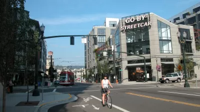
Portland will launch an effort to evaluate and improve its influential neighborhood greenway system of bike friendly residential corridors.
"A team of experts in [Portland's] transportation bureau will spend part of their time in the next few months looking closely at trends in how people use the [neighborhood greenway] system while biking, walking and driving," reports Michael Andersen. The study will produce a report in early 2015 intended to inform improvements to the greenway system.
Andersen reported in February of 2014 that the city had ceased expansions of the neighborhood greenways by eliminating dedicated funding for the network. The current proposal for the Portland Street Fund, an ongoing, controversial issue, would devote three percent of revenue to the neighborhood greenway network.
FULL STORY: City of Portland will take ‘deep dive’ into data to assess neighborhood greenway system

Portland Moves Forward with Revised 'Street Fund'
A revised proposal for the "Portland Street Fund," announced this week by the city's political leadership, aims to balance the needs of advocates of alternative transportation and that of the city's business community.
Portland Considering 'Street Fee' for Residents and Businesses
The Portland City Council moved quickly in proposing and revising a "street fee" to finance repairs on the city's crumbling roads. Now a more realistic calendar seems to be in place for considering the fee on residents and businesses.
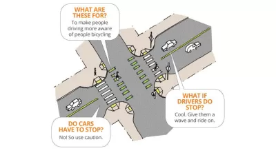
Portland Introduces 'Crossbikes'
It's like a crosswalk, but for bikes.

Planetizen Federal Action Tracker
A weekly monitor of how Trump’s orders and actions are impacting planners and planning in America.

Restaurant Patios Were a Pandemic Win — Why Were They so Hard to Keep?
Social distancing requirements and changes in travel patterns prompted cities to pilot new uses for street and sidewalk space. Then it got complicated.

Map: Where Senate Republicans Want to Sell Your Public Lands
For public land advocates, the Senate Republicans’ proposal to sell millions of acres of public land in the West is “the biggest fight of their careers.”

Maui's Vacation Rental Debate Turns Ugly
Verbal attacks, misinformation campaigns and fistfights plague a high-stakes debate to convert thousands of vacation rentals into long-term housing.

San Francisco Suspends Traffic Calming Amidst Record Deaths
Citing “a challenging fiscal landscape,” the city will cease the program on the heels of 42 traffic deaths, including 24 pedestrians.

California Homeless Arrests, Citations Spike After Ruling
An investigation reveals that anti-homeless actions increased up to 500% after Grants Pass v. Johnson — even in cities claiming no policy change.
Urban Design for Planners 1: Software Tools
This six-course series explores essential urban design concepts using open source software and equips planners with the tools they need to participate fully in the urban design process.
Planning for Universal Design
Learn the tools for implementing Universal Design in planning regulations.
Heyer Gruel & Associates PA
JM Goldson LLC
Custer County Colorado
City of Camden Redevelopment Agency
City of Astoria
Transportation Research & Education Center (TREC) at Portland State University
Camden Redevelopment Agency
City of Claremont
Municipality of Princeton (NJ)