


A new service provides transit users live, real-time displays of all transportation options within proximity to various locations in downtown Seattle, Washington.
As discussed on the Seattle Transit Blog by Frank Chiachiere, the Seattle Department of Transportation has teamed up with TransitScreen to provide readable multi-modal information to transit riders. The screens contain easy to read information on bus and rail arrival times, and bike-share and carshare location and availability, so that riders can make informed decisions as to their travel mode choice.
Following the lead of a number of other North American cities such as Washington D.C., San Francisco, Salt Lake City, and San Diego, Seattle has been working hard to implement new technologies making riding transit easier to understand and more transparent.
However, as Chiachiere points out, Seattle still does not have a standardized wayfinding method to pinpoint transit locations, like Vignelli’s 1970 standards manual for New York’s MTA, making the new implementation of TransitScreen perhaps preemptive.
FULL STORY: TransitScreen Launches Downtown

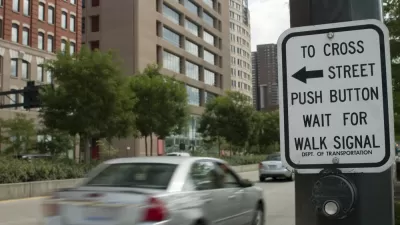
Seattle Recalculates Walk Signal Timing to Make Crossings Safer for Pedestrians
The new formulas for calculating the length of walk signals are designed to give people more time to safely cross the street.

Seattle Neighborhood Groups Propose Aerial Gondola to Replace Light Rail Expansion
Impatient with the city's light rail expansion plans, some residents are looking to aerial gondolas as a new mode of public transit.

Seattle Plans to Connect Bike Network by 2020
Downtown Seattle has many disconnected bike lanes, so to make sure there are more safe routes for bikers, the city council passed a resolution that sets out a timeline to connect them.

Planetizen Federal Action Tracker
A weekly monitor of how Trump’s orders and actions are impacting planners and planning in America.

Restaurant Patios Were a Pandemic Win — Why Were They so Hard to Keep?
Social distancing requirements and changes in travel patterns prompted cities to pilot new uses for street and sidewalk space. Then it got complicated.

Map: Where Senate Republicans Want to Sell Your Public Lands
For public land advocates, the Senate Republicans’ proposal to sell millions of acres of public land in the West is “the biggest fight of their careers.”

Maui's Vacation Rental Debate Turns Ugly
Verbal attacks, misinformation campaigns and fistfights plague a high-stakes debate to convert thousands of vacation rentals into long-term housing.

San Francisco Suspends Traffic Calming Amidst Record Deaths
Citing “a challenging fiscal landscape,” the city will cease the program on the heels of 42 traffic deaths, including 24 pedestrians.

California Homeless Arrests, Citations Spike After Ruling
An investigation reveals that anti-homeless actions increased up to 500% after Grants Pass v. Johnson — even in cities claiming no policy change.
Urban Design for Planners 1: Software Tools
This six-course series explores essential urban design concepts using open source software and equips planners with the tools they need to participate fully in the urban design process.
Planning for Universal Design
Learn the tools for implementing Universal Design in planning regulations.
Heyer Gruel & Associates PA
JM Goldson LLC
Custer County Colorado
City of Camden Redevelopment Agency
City of Astoria
Transportation Research & Education Center (TREC) at Portland State University
Camden Redevelopment Agency
City of Claremont
Municipality of Princeton (NJ)