


Bus rapid transit (BRT) is well known among planners as a cheap method to improve bus service and provide an alternative to rail, but BRT projects around the country have met resistance from an array of status quo interests.
Yonah Freemark argues in favor of a more widespread adoption of bus rapid transit (BRT). “With projects like BRT, we have an opportunity to play to the great advantages of dense, urban environments, where transit is truly effective in connecting people to jobs and other needs, if given the chance to thrive.”
Freemark details the benefits of removing bus traffic from automobile traffic, and cites the successes of BRT projects. For example, “in city after city, BRT services have indeed increased ridership,” and “businesses fearful of fewer cars driving down streets with BRT should comfort themselves with the fact that more transit users typically means more economic activity, not less.”
Freemark drills a little deeper on the example of Chicago’s BRT line on Ashland Avenue: “For people living near several stations, the number of jobs accessible within a 20-minute transit commute would increase by more than 80 percent. The line itself would increase the number of people living and working within a quarter mile of a rapid transit station by 80,000 and 25,000, respectively.”
FULL STORY: Why More U.S. Cities Need to Embrace Bus-Rapid Transit

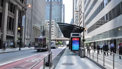
Op-Ed: Invest More in Chicago's Buses
In addition to funding the city's roadways and trains, Chicago could use new federal infrastructure dollars to shore up its bus system and invest in bus rapid transit that would improve service for riders.

Bus Advocates: Chicago BRT Plan Could Be Better
The Central Loop BRT project, scheduled to break ground this month, will improve commuter travel times. But a collection of compromises means many ideal BRT components won't be installed.
Palo Alto Electeds Oppose Dedicated Lanes for El Camino BRT
As the Santa Clara Valley Transportation Authority (VTA) considers the environmental analysis for a proposed bus rapid transit lane in Palo Alto, local officials are opposing the version of the plan that would remove parking for a dedicated bus lane.

Planetizen Federal Action Tracker
A weekly monitor of how Trump’s orders and actions are impacting planners and planning in America.

Restaurant Patios Were a Pandemic Win — Why Were They so Hard to Keep?
Social distancing requirements and changes in travel patterns prompted cities to pilot new uses for street and sidewalk space. Then it got complicated.

Maui's Vacation Rental Debate Turns Ugly
Verbal attacks, misinformation campaigns and fistfights plague a high-stakes debate to convert thousands of vacation rentals into long-term housing.

Boulder Eliminates Parking Minimums Citywide
Officials estimate the cost of building a single underground parking space at up to $100,000.

Orange County, Florida Adopts Largest US “Sprawl Repair” Code
The ‘Orange Code’ seeks to rectify decades of sprawl-inducing, car-oriented development.

Maui's Vacation Rental Debate Turns Ugly
Verbal attacks, misinformation campaigns and fistfights plague a high-stakes debate to convert thousands of vacation rentals into long-term housing.
Urban Design for Planners 1: Software Tools
This six-course series explores essential urban design concepts using open source software and equips planners with the tools they need to participate fully in the urban design process.
Planning for Universal Design
Learn the tools for implementing Universal Design in planning regulations.
Heyer Gruel & Associates PA
JM Goldson LLC
Custer County Colorado
City of Camden Redevelopment Agency
City of Astoria
Transportation Research & Education Center (TREC) at Portland State University
Camden Redevelopment Agency
City of Claremont
Municipality of Princeton (NJ)