


The Congress for the New Urbanism releases a Top 10 list highlighting the worst, most ready-to-be-junked urban freeways. New Orleans, Syracuse, and Detroit make the list. Boulevards are a viable and much-needed alternative, says CNU.

Back in the days of Robert Moses, it became a sign of progress to thrust freeways directly into and through American cities. A handful of grassroots groups fought back and stopped some freeways at the gates, but most cities gained elevated highways and lost historic neighborhoods. But there is a growing understanding that turning urban highway stubs into at-grade boulevards restores the urban fabric, opens up new and valuable infill opportunities, and still manages to move cars efficiently.
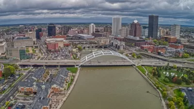
The Top 10 Freeways Without Futures are not ranked by CNU, but Claiborne Expressway in New Orleans is presented first and makes a compelling case. New York State, Robert Moses' bailiwick, takes up 3 of the 10 top slots with freeways in Rochester, Syracuse and Buffalo. CNU selected the Top 10 by looking at factors such as the age of the freeway, the development potential, the timeliness of the project, and local support for the teardown.
Click through to cnu.org for the full list.
FULL STORY: CNU Selects the Top 10 "Freeways Without Futures" for 2014

Support Builds For Highway Removal in Saint Louis
St. Louis Post-Dispatch editorial board formally endorses the removal of elevated and depressed lanes of current I-70 ROW to reconnect city and arch grounds.

Dead End: Nine Highways Ready for Retirement
The Freeways Without Futures report describes the nation’s most promising highway removal proposals.
Rochester Shows Possible Future for Former Highways
A former freeway is undergoing a massive redevelopment that goes beyond highway removal to reconnect and revitalize surrounding areas.

Planetizen Federal Action Tracker
A weekly monitor of how Trump’s orders and actions are impacting planners and planning in America.

Maui's Vacation Rental Debate Turns Ugly
Verbal attacks, misinformation campaigns and fistfights plague a high-stakes debate to convert thousands of vacation rentals into long-term housing.

Restaurant Patios Were a Pandemic Win — Why Were They so Hard to Keep?
Social distancing requirements and changes in travel patterns prompted cities to pilot new uses for street and sidewalk space. Then it got complicated.

In California Battle of Housing vs. Environment, Housing Just Won
A new state law significantly limits the power of CEQA, an environmental review law that served as a powerful tool for blocking new development.

Boulder Eliminates Parking Minimums Citywide
Officials estimate the cost of building a single underground parking space at up to $100,000.

Orange County, Florida Adopts Largest US “Sprawl Repair” Code
The ‘Orange Code’ seeks to rectify decades of sprawl-inducing, car-oriented development.
Urban Design for Planners 1: Software Tools
This six-course series explores essential urban design concepts using open source software and equips planners with the tools they need to participate fully in the urban design process.
Planning for Universal Design
Learn the tools for implementing Universal Design in planning regulations.
Heyer Gruel & Associates PA
JM Goldson LLC
Custer County Colorado
City of Camden Redevelopment Agency
City of Astoria
Transportation Research & Education Center (TREC) at Portland State University
Jefferson Parish Government
Camden Redevelopment Agency
City of Claremont