


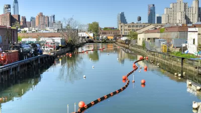
The EPA has released plans for how it intends to clean up Brooklyn's Gowanus Canal Superfund site. Branden Klayko reports on the $500 million, two pronged approach.
Brooklyn's 1.8-mile-long Gowanus Canal is at once one of New York's most toxic environments and the centerpiece of what could one day become one of the city's most sought after neighborhoods. Klayko reviews the $500 million plan outlined by the Environmental Protection Agency (EPA), in collaboration with the New York State Department of Environmental Conservation (NYSDEC), that will facilitate this transformation. The "dual approach", would "dredge and cap the canal bottom and improve the city’s combined sewer overflow (CSO) problem that dumps raw sewage and other contaminants into the canal during heavy rainfall."
"To remove existing contaminants deposited by 150 years of industrial use from factories, tanneries, and refineries, ten feet of sediment from two heavily contaminated portions of the canal will be removed and capped with a mix of concrete, clay, and sand," explains Klayko. "A less-contaminated segment will also be dredged and capped with sand."
"Two underground retention basins costing $78 million are proposed at two of the worst CSO sites, to store sewage until nearby water treatment facilities can handle it. Smaller-scale improvements, including green storm-water management, to capture and hold rainwater on surrounding streets, and an environmental restoration project, the Gowanus Canal Sponge Park, designed by Brooklyn-based dlandstudio and funded by city and federal grants, will also help reduce storm-water discharges."
FULL STORY: Water Wash

Residents Near Brooklyn Enviro Cleanup Fear 'Cure Is Worse Than the Disease'
Residents living near Brooklyn's toxic Gowanus Canal are fighting the E.P.A.'s $500 million environmental cleanup effort over disagreement with the methods proposed by the agency. Will their opposition thwart the long-sought remediation.
Big Day for Brooklyn: Gowanus Canal Clean Up Begins
Local advocates are celebrating the start of clean up work on the Gowanus Canal in Brooklyn.
Will a Brooklyn Superfund Site Become the Borough's Next Hot Nabe?
On-again, off-again, and now back on-again plans to redevelop the polluted area between two of Brooklyn's most affluent neighborhoods have the residents of Gowanus divided on the direction of their gritty community.

Planetizen Federal Action Tracker
A weekly monitor of how Trump’s orders and actions are impacting planners and planning in America.

Map: Where Senate Republicans Want to Sell Your Public Lands
For public land advocates, the Senate Republicans’ proposal to sell millions of acres of public land in the West is “the biggest fight of their careers.”

Restaurant Patios Were a Pandemic Win — Why Were They so Hard to Keep?
Social distancing requirements and changes in travel patterns prompted cities to pilot new uses for street and sidewalk space. Then it got complicated.

Platform Pilsner: Vancouver Transit Agency Releases... a Beer?
TransLink will receive a portion of every sale of the four-pack.

Toronto Weighs Cheaper Transit, Parking Hikes for Major Events
Special event rates would take effect during large festivals, sports games and concerts to ‘discourage driving, manage congestion and free up space for transit.”

Berlin to Consider Car-Free Zone Larger Than Manhattan
The area bound by the 22-mile Ringbahn would still allow 12 uses of a private automobile per year per person, and several other exemptions.
Urban Design for Planners 1: Software Tools
This six-course series explores essential urban design concepts using open source software and equips planners with the tools they need to participate fully in the urban design process.
Planning for Universal Design
Learn the tools for implementing Universal Design in planning regulations.
Heyer Gruel & Associates PA
JM Goldson LLC
Custer County Colorado
City of Camden Redevelopment Agency
City of Astoria
Transportation Research & Education Center (TREC) at Portland State University
Camden Redevelopment Agency
City of Claremont
Municipality of Princeton (NJ)