


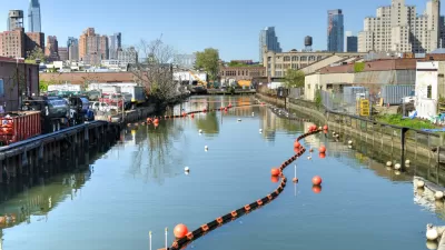
On-again, off-again, and now back on-again plans to redevelop the polluted area between two of Brooklyn's most affluent neighborhoods have the residents of Gowanus divided on the direction of their gritty community.
Plans by the Lightstone Group to develop 700 rental apartments along the polluted Gowanus Canal, conveniently located a short walk from the historic brownstones of the Park Slope and Carroll Gardens neighborhoods of Brooklyn, and a similarly sized project in the vicinity, have residents of the "quirky and rough-edged" neighborhood divided over its future, reports Joseph Berger.
"Some residents are trying to block or reduce the scale of the proposed
buildings, arguing that the new tenants would overwhelm schools and
subways, and that the buildings themselves - 12 stories in spots - would
perniciously transform the low-rise mingling of factories and row
houses they have come to love. Others, however, argue that the
Lightstone development would create a constituency to lobby for
continuing the cleanup of the sometimes inky, sometimes lizard-green
waters of the 1.8-mile polluted and pathogenic canal, which was declared a Superfund site in 2010."
"'This is the tipping point for Gowanus,' said Jerome Krase, a professor
emeritus of sociology at Brooklyn College and a former president of the Gowanus Canal Community Development Corporation,
a neighborhood group. 'What's going to be interesting is to see whether
it's going to contribute to a kind of middle- and upper-middle-income
neighborhood in between gentrified Carroll Gardens and highly gentrified
Park Slope. What's unusual about this project is it's being done in the
middle of the wasteland.'"
FULL STORY: Grand Plan for a Toxic Site Is Scorned and Celebrated

Big Day for Brooklyn: Gowanus Canal Clean Up Begins
Local advocates are celebrating the start of clean up work on the Gowanus Canal in Brooklyn.
Opening the 'Superfund' Can of Worms
The EPA's proposal to list the Gowanus Canal as a Superfund site is getting mixed reactions from nearby residents and officials: some see the designation as a development-halting stigma, others as quite the opposite.

Gowanus Rezoning Clears Post-Approval Legal Hurdle
The saga of the Gowanus Neighborhood Planning Study, approved by New York City at the end of 2021, continues into the summer of 2022. Opponents claimed the Gowanus rezoning ran afoul of the state’s environment law. A county judge dismissed the case.

Maui's Vacation Rental Debate Turns Ugly
Verbal attacks, misinformation campaigns and fistfights plague a high-stakes debate to convert thousands of vacation rentals into long-term housing.

Planetizen Federal Action Tracker
A weekly monitor of how Trump’s orders and actions are impacting planners and planning in America.

In Urban Planning, AI Prompting Could be the New Design Thinking
Creativity has long been key to great urban design. What if we see AI as our new creative partner?

Portland Raises Parking Fees to Pay for Street Maintenance
The city is struggling to bridge a massive budget gap at the Bureau of Transportation, which largely depleted its reserves during the Civd-19 pandemic.

Spokane Mayor Introduces Housing Reforms Package
Mayor Lisa Brown’s proposals include deferring or waiving some development fees to encourage more affordable housing development.

Houston Mayor Kills Another Bike Lane
The mayor rejected a proposed bike lane in the Montrose district in keeping with his pledge to maintain car lanes.
Urban Design for Planners 1: Software Tools
This six-course series explores essential urban design concepts using open source software and equips planners with the tools they need to participate fully in the urban design process.
Planning for Universal Design
Learn the tools for implementing Universal Design in planning regulations.
Gallatin County Department of Planning & Community Development
Heyer Gruel & Associates PA
JM Goldson LLC
City of Camden Redevelopment Agency
City of Astoria
Transportation Research & Education Center (TREC) at Portland State University
Jefferson Parish Government
Camden Redevelopment Agency
City of Claremont