


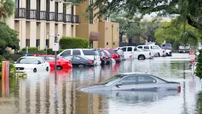
Adapting to extreme weather events resulting from climate change has largely taken the form of infrastructure engineering, e.g building flood doors for subways or reinforcing sand dunes, but what of 'social adaptation' for residents themselves?
In the abstract to "Adaptation", professor of sociology at New York University, Eric Klinenberg writes on the need to “climate-proof” cities —"protecting people, businesses, and critical infrastructure against weather-related calamities."
"Increasingly, governments and disaster planners are recognizing the importance of social infrastructure: the people, places, and institutions that foster cohesion and support.
Klinenberg "discusses, at length, the case of a deadly 1995 heat wave in Chicago, during which people living in neighborhoods with stronger social networks fared better than people who lived in comparable, but less socially cohesive, neighborhoods."
To access the article itself, one needs a New Yorker subscription or the Jan. 07 edition. However, he discusses his findings with National Public Radio's Steve Inskeep on 'Morning Edition" on January 3.
Klinenberg describes a 'socially cohesive neighborhood' essentially as being walkable with small-scale retail that "draws older people into public life". The two neighborhoods he compares are adjacent, poor, "nearly identical" and have many older residents. The walkable neighborhood had fewer deaths from the heat wave, and whose residents have longer life expectancy, showing that social infrastructure made a difference in residents' lives regardless of extreme weather.
Audio and podcast available.
FULL STORY: ADAPTATION - Dept. Of Urban Planning, Abstract: How can cities be “climate-proofed”?

20 States Best and Least Prepared for Climate Change and Extreme Weather
A new study from CNBC ranks US states in order of sustainability and preparedness for climate change and extreme weather. A few might surprise you.
Chicago Was Already Wiping Out Trees. Then the Derecho Hit.
An Urban Forestry Board is needed in Chicago to unsure the health and safety benefits of a flourishing urban forest.
Op-Ed: Good Design Isn't Just for Downtowns
Richard Driehaus attests to the importance of intentional, context-oriented design on the neighborhood level.

Planetizen Federal Action Tracker
A weekly monitor of how Trump’s orders and actions are impacting planners and planning in America.

Restaurant Patios Were a Pandemic Win — Why Were They so Hard to Keep?
Social distancing requirements and changes in travel patterns prompted cities to pilot new uses for street and sidewalk space. Then it got complicated.

Map: Where Senate Republicans Want to Sell Your Public Lands
For public land advocates, the Senate Republicans’ proposal to sell millions of acres of public land in the West is “the biggest fight of their careers.”

Maui's Vacation Rental Debate Turns Ugly
Verbal attacks, misinformation campaigns and fistfights plague a high-stakes debate to convert thousands of vacation rentals into long-term housing.

San Francisco Suspends Traffic Calming Amidst Record Deaths
Citing “a challenging fiscal landscape,” the city will cease the program on the heels of 42 traffic deaths, including 24 pedestrians.

California Homeless Arrests, Citations Spike After Ruling
An investigation reveals that anti-homeless actions increased up to 500% after Grants Pass v. Johnson — even in cities claiming no policy change.
Urban Design for Planners 1: Software Tools
This six-course series explores essential urban design concepts using open source software and equips planners with the tools they need to participate fully in the urban design process.
Planning for Universal Design
Learn the tools for implementing Universal Design in planning regulations.
Heyer Gruel & Associates PA
JM Goldson LLC
Custer County Colorado
City of Camden Redevelopment Agency
City of Astoria
Transportation Research & Education Center (TREC) at Portland State University
Camden Redevelopment Agency
City of Claremont
Municipality of Princeton (NJ)