


Transportation for America (TfA), a campaign to strengthen the nation’s transportation network, released an update to its “Dangerous by Design” report, an analysis of pedestrian safety in the design and use of American streets.
Transportation for America (TfA), a campaign to strengthen the nation's transportation network, released an update to its "Dangerous by Design" report, an analysis of pedestrian safety in the design and use of American streets. Accompanying the report, TfA ranked the country's largest metropolitan areas according to their relative risk to walkers and released a map of fatalities, separated by state. The statistics show Florida cities as rounding the top four most dangerous metropolitan areas for pedestrians. Orlando-Kissimmee, Tampa-St. Petersburg-Clearwater, Jacksonville and Miami-Fort Lauderdale-Pompano Beach metropolitan areas have the highest pedestrian danger index, a value computed using ten years of pedestrian fatality data and the newly-released Census walking data.
"Orlando tops the list of most dangerous places because of its high pedestrian fatality rate of 3.0 per 100,000 people, despite only 1.2 percent of people walking to work" the report explains. "In other words, the few people who do walk in Orlando face a relatively high risk of being killed in a traffic crash."
Thanks to Jeffrey Riecke
FULL STORY: New Report: Measuring Pedestrian Safety in the U.S.

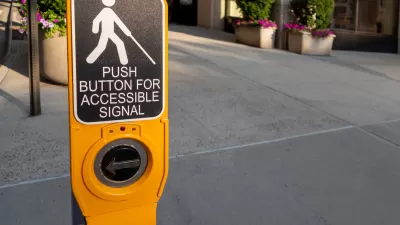
Chicago Made Hundreds of Accessibility Upgrades in 2024
The city has improved over 200 bus stops and 400 of its nearly 3,000 intersections to make them safer for people with disabilities.

Street Safety Improvements Coming to the Bay Area
State and local officials are zeroing in on some of the region’s most dangerous streets and transit corridors.
Florida Law Targets ‘Activist’ Road Diets
Gov. DeSantis signed a transportation law that complicates the process for lane reductions, despite the rising number of pedestrian deaths in the state.

Planetizen Federal Action Tracker
A weekly monitor of how Trump’s orders and actions are impacting planners and planning in America.

Maui's Vacation Rental Debate Turns Ugly
Verbal attacks, misinformation campaigns and fistfights plague a high-stakes debate to convert thousands of vacation rentals into long-term housing.

San Francisco Suspends Traffic Calming Amidst Record Deaths
Citing “a challenging fiscal landscape,” the city will cease the program on the heels of 42 traffic deaths, including 24 pedestrians.

Defunct Pittsburgh Power Plant to Become Residential Tower
A decommissioned steam heat plant will be redeveloped into almost 100 affordable housing units.

Trump Prompts Restructuring of Transportation Research Board in “Unprecedented Overreach”
The TRB has eliminated more than half of its committees including those focused on climate, equity, and cities.

Amtrak Rolls Out New Orleans to Alabama “Mardi Gras” Train
The new service will operate morning and evening departures between Mobile and New Orleans.
Urban Design for Planners 1: Software Tools
This six-course series explores essential urban design concepts using open source software and equips planners with the tools they need to participate fully in the urban design process.
Planning for Universal Design
Learn the tools for implementing Universal Design in planning regulations.
Heyer Gruel & Associates PA
JM Goldson LLC
Custer County Colorado
City of Camden Redevelopment Agency
City of Astoria
Transportation Research & Education Center (TREC) at Portland State University
Jefferson Parish Government
Camden Redevelopment Agency
City of Claremont