


Suburban areas are increasingly in the sights of planners and designers who are thinking of new ways to reform the sprawled out land use patterns. This interview looks at how those efforts relate to Houston.
Sustainable development experts Galina Tachieva and Tom Low talk about the problems faced in the suburbs of Houston and the rest of the U.S.
"Galina: In Houston there are many examples of places which are entirely auto-oriented. We call them sprawl patterns. And they're actually typical, not only for Houston, they're typical and normative and standard for the rest of the country. And so we believe that some of these places have out-lived their kind of life. And it would be much better if they are turned into mix-use and walkable places. Right now they are single use.
Wendy: Why is that better?
Galina: Because these places - single family residential developments, or the typical malls, shopping centers, office parks - they are single-use, very auto-oriented, separated pods of development. And they need to be rebalanced with different uses so people can walk to destinations."
FULL STORY: De-Sprawling Houston

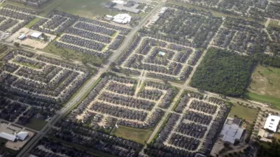
Houston Area's Center of Gravity Shifts Outside the Loop
The population center of Harris County is now outside central Houston, a shift that occurred over the last two decades as the region's suburbs blossomed.

The Natalist Case For Sprawl (And Why It Fails)
Some commentators defend anti-urban government policies such as exclusionary zoning on the basis that homeowning suburbanites have high birth rates. But this doesn't seem to be true in recent decades.

Zoning for Good
A new book highlights the power of zoning to change communities for the better.

Planetizen Federal Action Tracker
A weekly monitor of how Trump’s orders and actions are impacting planners and planning in America.

Map: Where Senate Republicans Want to Sell Your Public Lands
For public land advocates, the Senate Republicans’ proposal to sell millions of acres of public land in the West is “the biggest fight of their careers.”

Restaurant Patios Were a Pandemic Win — Why Were They so Hard to Keep?
Social distancing requirements and changes in travel patterns prompted cities to pilot new uses for street and sidewalk space. Then it got complicated.

Platform Pilsner: Vancouver Transit Agency Releases... a Beer?
TransLink will receive a portion of every sale of the four-pack.

Toronto Weighs Cheaper Transit, Parking Hikes for Major Events
Special event rates would take effect during large festivals, sports games and concerts to ‘discourage driving, manage congestion and free up space for transit.”

Berlin to Consider Car-Free Zone Larger Than Manhattan
The area bound by the 22-mile Ringbahn would still allow 12 uses of a private automobile per year per person, and several other exemptions.
Urban Design for Planners 1: Software Tools
This six-course series explores essential urban design concepts using open source software and equips planners with the tools they need to participate fully in the urban design process.
Planning for Universal Design
Learn the tools for implementing Universal Design in planning regulations.
Heyer Gruel & Associates PA
JM Goldson LLC
Custer County Colorado
City of Camden Redevelopment Agency
City of Astoria
Transportation Research & Education Center (TREC) at Portland State University
Camden Redevelopment Agency
City of Claremont
Municipality of Princeton (NJ)