


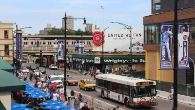
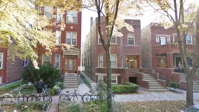
A few days ago, I was in a Chicago neighborhood called Lincoln Square, on Lincoln Avenue just south of Lawrence Avenue. Lincoln Avenue looks like many posh urban neighborhoods- narrow, walkable streets inhabited by gelato-eating, prosperous-looking people. Even on a weeknight, the shops and streets of Lincoln Square betrayed no evidence of a recession.*

A few days ago, I was in a Chicago neighborhood called Lincoln Square, on Lincoln Avenue just south of Lawrence Avenue. Lincoln Avenue looks like many posh urban neighborhoods- narrow, walkable streets inhabited by gelato-eating, prosperous-looking people. Even on a weeknight, the shops and streets of Lincoln Square betrayed no evidence of a recession.*
Lincoln intersects with Lawrence Avenue just a block from the core of Lincoln Square. Lawrence Avenue resembles a suburb more than it resembles Lincoln Square; it is six lanes wide (though unlike in most suburbs, two of them are used for parking), and some shops are behind parking lots. But Lawrence's retail is far less prosperous than that of Lincoln; a good number of Lawrence's storefronts seemed to be vacant, and others were occupied by dollar stores and other non-carriage trade businesses.**
Both Lincoln Avenue and Lawrence Avenue have the same housing stock and thus the same neighbors, the same city government (and thus the same tax rates and school districts) and the same distance from downtown (about seven miles). Thus, these two intersecting streets constitute the perfect controlled experiment on the popularity of walkable urbanism. If people basically liked shopping on car-oriented speedways, Lawrence would have fewer vacant storefronts than Lincoln. Yet the opposite is true. It follows that where everything else is equal, shoppers prefer walkable urbanism to car-oriented suburbanism.
At this point, readers may be asking themselves: why, then, do some suburbs continue to prosper? Because not everything else is equal: an unwalkable suburb may be further away from troubled neighborhoods (usually leading to more prestigous schools and less crime), in a less poverty-packed jurisdiction (thus leading to lower taxes), or have a newer housing stock. Thus, not every suburb will look as scruffy as Lincoln Square.
But the tale of these two adjacent streets nevertheless tells us something: that city life with walkability is appealing to American consumers, while city life with less walkability is anything but.
*For a few pictures of Lincoln Square, see
http://atlantaphotos.fotopic.net/p66205703.html
http://atlantaphotos.fotopic.net/p66205709.html
http://atlantaphotos.fotopic.net/p66205702.html
**Although I took no pictures of Lawrence, you can see the street by going to the 2200-2600 blocks of West Lawrence Avenue on Google Street View.

Chicago Plans ‘Better Streets for Buses’
The city of Chicago is taking first steps toward a commitment to better bus service in the design and configuration of the city's streets.
Report Links Housing Growth and Climate Resilience
Data from three U.S. metro areas show a failure to address land use and sprawl as a key factor driving climate change.
Research Shows '15-Minute City' Not Enough to Guarantee Equity
A study of Chicago neighborhoods showed that access to urban amenities does not necessarily correlate with improved economic outcomes.

Planetizen Federal Action Tracker
A weekly monitor of how Trump’s orders and actions are impacting planners and planning in America.

Map: Where Senate Republicans Want to Sell Your Public Lands
For public land advocates, the Senate Republicans’ proposal to sell millions of acres of public land in the West is “the biggest fight of their careers.”

Restaurant Patios Were a Pandemic Win — Why Were They so Hard to Keep?
Social distancing requirements and changes in travel patterns prompted cities to pilot new uses for street and sidewalk space. Then it got complicated.

Platform Pilsner: Vancouver Transit Agency Releases... a Beer?
TransLink will receive a portion of every sale of the four-pack.

Toronto Weighs Cheaper Transit, Parking Hikes for Major Events
Special event rates would take effect during large festivals, sports games and concerts to ‘discourage driving, manage congestion and free up space for transit.”

Berlin to Consider Car-Free Zone Larger Than Manhattan
The area bound by the 22-mile Ringbahn would still allow 12 uses of a private automobile per year per person, and several other exemptions.
Urban Design for Planners 1: Software Tools
This six-course series explores essential urban design concepts using open source software and equips planners with the tools they need to participate fully in the urban design process.
Planning for Universal Design
Learn the tools for implementing Universal Design in planning regulations.
Heyer Gruel & Associates PA
JM Goldson LLC
Custer County Colorado
City of Camden Redevelopment Agency
City of Astoria
Transportation Research & Education Center (TREC) at Portland State University
Camden Redevelopment Agency
City of Claremont
Municipality of Princeton (NJ)