


Managing Editor Tim Halbur reviews The High Line, the much-lauded new linear park in Manhattan.
The High Line opened a few weeks ago to rapturous reviews and a surfeit of coverage. The story is irresistible - how a ragtag community group came together to promote the idea of turning an abandoned stretch of elevated railway into a public park, and the city listened! A public-private partnership resulted: money was raised, miles of red tape were cut, and a most unusual park rose out of the Meatpacking District.
With so much written (and filmed- see 1, 2, and 3), I thought it best to step out of the picture and let The High Line speak for itself. Here's a portrait of the park on a sunny weekend in June:
A Walk On The High Line from Urban Insight on Vimeo.
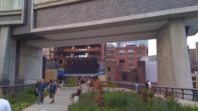
To me, the most remarkable aspect of the park is the way it redefines a number of stubbornly persistent beliefs in what a park should be. Firstly, of course, is the anti-urban idea that parks should recreate the wilderness. While the design incorporates the natural growths that sprung up on the site after its closing in 1980, the landscaping is sculpted and controlled. It also doesn't attempt to mask the urban scene: the views are paramount, from the sleek new contemporary building that straddles the park to the myriad brick and mortar buildings that surround it. The rusted railroad tracks of the past add a pleasant wabi sabi to the design.
The second myth of parks that The High Line easily dismisses is that parks have to be multi-use. Unlike the unloved 'open space' lots of the past, The High Line is not set up for soccer, barbeques, or kids gymnastics. A wide, uneven cement path winds through the landscape, a design that begs to be perambulated at a slower pace. It is more like a European boulevard than an American park. Sitting is also greatly encouraged -- understated benches are plentiful, and the loungers are wide and inviting.
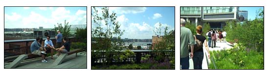
Finally, the modernist design and clean lines of the park feel like a vindication for the Dwell crowd. Public spaces across the country were marred by poor urbanism inflicted by modernists, but the subdued benches, slatted concrete, and glass and steel fences of The High Line all come together into a harmonious experience that traditional design would not have accomplished.
Much of the credit goes to James Corner Field Operations, the landscape architects. As James Corner, lead designer, said in an interview, "How do you keep that quality, this magical, found landscape in the city, and at the same time allow hundreds of people up there to walk, to stroll, to sit, and stand and enjoy views?" That is exactly what they've pulled off with The High Line.
A caveat: years ago when I was writing my masters' project on the problems of United Nations Plaza in San Francisco, I went to New York to find other public spaces to offer as comparisons. In the end, I had to conclude that New York's public parks and plazas are not comparable -- the constant flow of people in, around, and through the public spaces can be found nowhere else in this nation. Attempts to create elevated or sunken plazas in other cities have backfired, either sucking the life out of the surroundings or stagnating from disuse.
So for cities considering replicating the success of The High Line, a word of warning: don't try this at home.

Manhattan Residents Cling to Public Space Amid NYPD Crackdowns
The city's police has begun issuing citations and implementing curfews in public parks that became oases of social activity during the pandemic.
Meet Some of New York City's Newest Parks
In a city where density is everything, these park projects make creative use of existing public spaces—and, in some cases, create their own.
The All-New High Line
With travel restrictions requiring quarantines for many out-of-state visitors to New York City, the normal hordes of tourists on New York's High Line will be absent for months to come.

Planetizen Federal Action Tracker
A weekly monitor of how Trump’s orders and actions are impacting planners and planning in America.

Map: Where Senate Republicans Want to Sell Your Public Lands
For public land advocates, the Senate Republicans’ proposal to sell millions of acres of public land in the West is “the biggest fight of their careers.”

Restaurant Patios Were a Pandemic Win — Why Were They so Hard to Keep?
Social distancing requirements and changes in travel patterns prompted cities to pilot new uses for street and sidewalk space. Then it got complicated.

Platform Pilsner: Vancouver Transit Agency Releases... a Beer?
TransLink will receive a portion of every sale of the four-pack.

Toronto Weighs Cheaper Transit, Parking Hikes for Major Events
Special event rates would take effect during large festivals, sports games and concerts to ‘discourage driving, manage congestion and free up space for transit.”

Berlin to Consider Car-Free Zone Larger Than Manhattan
The area bound by the 22-mile Ringbahn would still allow 12 uses of a private automobile per year per person, and several other exemptions.
Urban Design for Planners 1: Software Tools
This six-course series explores essential urban design concepts using open source software and equips planners with the tools they need to participate fully in the urban design process.
Planning for Universal Design
Learn the tools for implementing Universal Design in planning regulations.
Heyer Gruel & Associates PA
JM Goldson LLC
Custer County Colorado
City of Camden Redevelopment Agency
City of Astoria
Transportation Research & Education Center (TREC) at Portland State University
Camden Redevelopment Agency
City of Claremont
Municipality of Princeton (NJ)