


Mayor Bloomberg and Janette Sadik-Khan have unveiled plans to turn a large segment of midtown into a pedestrian-only thoroughfare. The bold move is being applauded by livable street advocates across the United States.
"New York City Transportation Commissioner Janette Sadik-Khan unveiled plans to pedestrianize a large swath of Broadway in Midtown Manhattan at a small briefing in City Hall this morning. Intended to improve motor vehicle traffic flow, enhance safety and provide more and better public space to pedestrians, the plan seeks to solve what Sadik-Khan called a 'problem hidden in plain sight for 200 years.'
As the only Midtown street that pre-dates the 1811 street grid plan, Broadway "creates pinch points and traffic congestion as it traverses Manhattan crossing busy avenues," Sadik-Khan said. Extending from 59th Street at Columbus Circle to 23rd Street at Madison Square with substantial pedestrian-only areas at Times and Herald Squares, Mayor Bloomberg's plan for Broadway is, arguably, the boldest and most transformative street reclamation project since Portland, Oregon decided to tear down the Mt. Hood Freeway in 1974."
FULL STORY: Bloomberg Puts Forward a Bold, Transformative New Vision for Broadway

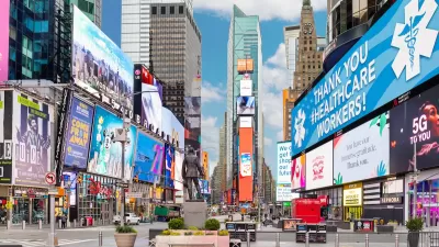
NYC Officials Announce Broadway Pedestrianization Project
Two blocks of the marquee street will become mostly car-free public spaces.
Sadik-Khan: NYC Congestion Pricing Program Potentially ‘Transformative’—If Done Right
The former transportation commissioner says the city must ensure the program isn’t “all stick and no carrot to succeed.

Protected Bike Lanes: How New York City Made It Happen
While resistance to protected bike lanes can be high, the economic and safety paybacks are substantial.

Planetizen Federal Action Tracker
A weekly monitor of how Trump’s orders and actions are impacting planners and planning in America.

Maui's Vacation Rental Debate Turns Ugly
Verbal attacks, misinformation campaigns and fistfights plague a high-stakes debate to convert thousands of vacation rentals into long-term housing.

San Francisco Suspends Traffic Calming Amidst Record Deaths
Citing “a challenging fiscal landscape,” the city will cease the program on the heels of 42 traffic deaths, including 24 pedestrians.

Amtrak Rolls Out New Orleans to Alabama “Mardi Gras” Train
The new service will operate morning and evening departures between Mobile and New Orleans.

The Subversive Car-Free Guide to Trump's Great American Road Trip
Car-free ways to access Chicagoland’s best tourist attractions.

San Antonio and Austin are Fusing Into one Massive Megaregion
The region spanning the two central Texas cities is growing fast, posing challenges for local infrastructure and water supplies.
Urban Design for Planners 1: Software Tools
This six-course series explores essential urban design concepts using open source software and equips planners with the tools they need to participate fully in the urban design process.
Planning for Universal Design
Learn the tools for implementing Universal Design in planning regulations.
Heyer Gruel & Associates PA
JM Goldson LLC
Custer County Colorado
City of Camden Redevelopment Agency
City of Astoria
Transportation Research & Education Center (TREC) at Portland State University
Jefferson Parish Government
Camden Redevelopment Agency
City of Claremont