


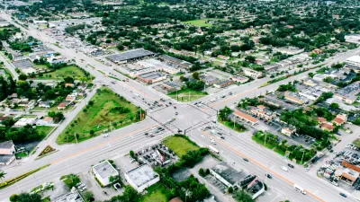
Calgary is poised to make itself into a city that encourages density without sacrificing too much of the leg room currently offered by existing suburbs.
"'Right now, we are stuck in a freeway superstructure-based network of segregated land uses that keeps all the houses away from many shops and employment and really forces everybody to own and operate a vehicle,'" says former real estate developer Jim Dewald, now an expert in global management at the Haskayne School of Business.
It may seem a stretch, but you must aim for the stars if you want to hit the moon, says David Watson, a veteran city planning manager who is determined not to let this plan be shelved."
"Ald. Ric McIver, whose ward borders Anderson station, says the city should prepare more modest, five-year growth proposals instead of the radical change of 30-year plans.
'If you take a 4,000-person community and you say to them we're going to put 4,000 more people in, you scare people that their quality of life is going to be ruined, and I can't blame them,' he says.
Developers face no such neighbourhood resistance as they expand on the periphery."
FULL STORY: Planning for the future city with a vision

Florida Law Would Change the Definition of ‘Sprawl’
One quick way to build sprawl.
Seattle Ponders a New Approach to Zoning for its Comprehensive Plan Update
The city of Seattle will have an updated comprehensive plan by the end of 2024, with zoning changes to follow by 2025.
Different Approaches to Fast Growth in Idaho's Treasure Valley
Three cities on the periphery of the fast-growing Treasure Valley showcase different approaches to a sudden influx of newcomers.

Planetizen Federal Action Tracker
A weekly monitor of how Trump’s orders and actions are impacting planners and planning in America.

Map: Where Senate Republicans Want to Sell Your Public Lands
For public land advocates, the Senate Republicans’ proposal to sell millions of acres of public land in the West is “the biggest fight of their careers.”

Restaurant Patios Were a Pandemic Win — Why Were They so Hard to Keep?
Social distancing requirements and changes in travel patterns prompted cities to pilot new uses for street and sidewalk space. Then it got complicated.

Platform Pilsner: Vancouver Transit Agency Releases... a Beer?
TransLink will receive a portion of every sale of the four-pack.

Toronto Weighs Cheaper Transit, Parking Hikes for Major Events
Special event rates would take effect during large festivals, sports games and concerts to ‘discourage driving, manage congestion and free up space for transit.”

Berlin to Consider Car-Free Zone Larger Than Manhattan
The area bound by the 22-mile Ringbahn would still allow 12 uses of a private automobile per year per person, and several other exemptions.
Urban Design for Planners 1: Software Tools
This six-course series explores essential urban design concepts using open source software and equips planners with the tools they need to participate fully in the urban design process.
Planning for Universal Design
Learn the tools for implementing Universal Design in planning regulations.
Heyer Gruel & Associates PA
JM Goldson LLC
Custer County Colorado
City of Camden Redevelopment Agency
City of Astoria
Transportation Research & Education Center (TREC) at Portland State University
Camden Redevelopment Agency
City of Claremont
Municipality of Princeton (NJ)