New York’s Department of Transportation plans to double the width of a Staten Island street to accommodate more vehicular traffic.


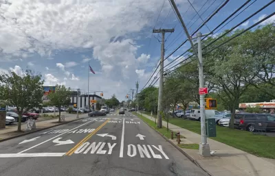
New York City officials plan to double the width of a street in Staten Island in a bid to reduce congestion, but mobility advocates say the plan will take away pedestrian space, make the street more dangerous for people with disabilities, and induce more traffic.
As Kevin Duggan explains in Streetsblog NYC, “The $24-million reconstruction of Amboy Road, covering less than a half-mile between Richmond and Armstrong avenues in Eltingville, will double the street's width from 40 feet to 80 feet to expand it from one lane each way to two, according to Department of Transportation plans dating back a decade.”
According to NYCDOT, “The plans would not only widen Amboy Road, but also also install a raised median and enhanced pedestrian crossings at intersections, which officials say would create a ‘Town Center’ environment.”
The project plan does not specify any improvements to transit along the corridor. “The project is being undertaken by DOT and the Department of Design and Construction, and it is set to start construction next spring. The DOT declined to respond to repeated questions about this project, but DDC spokesperson Ian Michaels said the project is still undergoing a final design.”
Read the full story: Vision? Zero! City Will Widen Staten Island Roadway to Appease Drivers

Planning for Congestion Relief
The third and final installment of Planetizen's examination of the role of the planning profession in both perpetuating and solving traffic congestion.

How Planning Fails to Solve Congestion
Solutions for congestion are never as simple and easy as armchair planners and engineers would like you to believe—especially those who suggest that congestion can be solved by forever building more roadway capacity.
Planning and the Complicated Causes and Effects of Congestion
What do planners know about congestion, and what can they do about it? Explanations and solutions are less obvious than they seem (part one of a three-part series).

Planetizen Federal Action Tracker
A weekly monitor of how Trump’s orders and actions are impacting planners and planning in America.

California plans to bury El Niño’s downpour
If the state plays its cards right, it may be able to store a billion acre-feet of El Niño’s water in aquifers.

Chicago breaks ground on $3 billion megadevelopment
The new neighborhood, titled Foundry Park, will one day host 3,700 residences.

Satanic place names
From streams and lakes to valleys and canyons, I mapped more than 1,000 places named after the Devil.

California High-Speed Rail Authority CEO resigns after $600,000 scandal
Under Ian Choudri, the authority used taxpayer dollars to fund first class flights and trips to nightclubs.

Want to study the Missouri River? Soon, you may need unanimous approval from 10 states
Legislation would require 10 governors’ permission to study or build projects moving water outside the basin.

FREE Course: Walkable City 1: Why Walkability?
After describing his path towards focusing on walkability as the essence of good planning, Jeff Speck marches through his five principal reasons for making more walkable places.
Reinventing Malls: Planning Alchemy—Turning Gray Fields Into Gold
The course focuses on the opportunities and imperatives that shape reinvention of mall sites.

City of Rosemead
Rutgers University, Edward J. Bloustein School of Planning and Public Policy
One Hundred Miles
Hunter College, City University of New York (CUNY)
The Architects Foundation
University of Cincinnati Online
City of Cambridge
Montrose County
The Pocatello Development Authority