


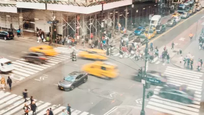
Data from New York City show that traffic safety projects that give pedestrians the most space are the most effective in reducing fatal crashes and injuries.

“New data published by the New York City Department of Transportation adds to a growing body of evidence about which interventions most effectively reduce traffic deaths and serious injuries.” In an article for Governing, Jared Brey describes the projects that had the biggest effect on street safety.
“The data show substantial reductions in serious injuries and fatalities for all roadway users resulting from street improvement projects like road diets, pedestrian islands, curb and sidewalk extensions, and leading pedestrian intervals — all on the order of 30 percent or more.” Brey adds that turn calming and protected bike lanes also had an impact of 15 percent of more.
The study, originally undertaken to analyze the effect of interventions on senior citizens, was broadened to include all road users. Brey notes that “Injury data specifically for cyclists were not included in the study, though a separate 2021 report looked at the impact of street interventions on risks for bikers.”
According to the study, projects that give pedestrians more space show the best results. “Another important takeaway was that conventional bike lanes, which involve little more than paint, did result in significantly fewer deaths and serious injuries.” While protected bike lanes help more, all designated bike lanes seem to have some effect on reducing dangerous crashes.
According to Beth Osborne, director of Transportation for America and vice president of transportation and thriving communities for Smart Growth America, New York City should serve as a model for planning, implementing, and then studying the results of traffic calming projects. “The tragedy is NYC DOT is a standout. We almost never check on what state DOTs or city DOTs promise.”
FULL STORY: What Are the Best Safe-Streets Improvements?

NYC Pedestrian Deaths Rose in 2024
The city’s Vision Zero efforts seem to have stalled.
Portland Traffic Deaths Surpass 2022 Number
This year, 69 people have died in traffic crashes in Portland, Oregon, nearly twice as many as in 2018, when the city began its Vision Zero program.
How “Proven Safety Countermeasures” Save Lives
A bill named in honor of a U.S. diplomat killed while on her bicycle would let state DOTs access full federal funding for road safety projects.

Rethinking Redlining
For decades we have blamed 100-year-old maps for the patterns of spatial racial inequity that persist in American cities today. An esteemed researcher says: we’ve got it all wrong.

Planetizen Federal Action Tracker
A weekly monitor of how Trump’s orders and actions are impacting planners and planning in America.

Walmart Announces Nationwide EV Charging Network
The company plans to install electric car chargers at most of its stores by 2030.

Seattle’s Pike Place Market Leans Into Pedestrian Infrastructure
After decades of debate, the market is testing a car ban in one of its busiest areas and adding walking links to the surrounding neighborhood.

The World’s Longest Light Rail Line is in… Los Angeles?
In a city not known for its public transit, the 48.5-mile A Line is the longest of its kind on the planet.

Quantifying Social Infrastructure
New developments have clear rules for ensuring surrounding roads, water, and sewers can handle new users. Why not do the same for community amenities?
Urban Design for Planners 1: Software Tools
This six-course series explores essential urban design concepts using open source software and equips planners with the tools they need to participate fully in the urban design process.
Planning for Universal Design
Learn the tools for implementing Universal Design in planning regulations.
City of Moorpark
City of Tustin
City of Camden Redevelopment Agency
City of Astoria
Transportation Research & Education Center (TREC) at Portland State University
Regional Transportation Commission of Southern Nevada
Toledo-Lucas County Plan Commissions