


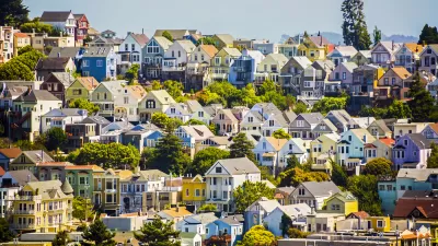
In search of space and affordability, American families are increasingly moving to suburbs and exurbs.

Suburban sprawl is nothing new to U.S. cities, but, as we have noted repeatedly over the last two years, the pandemic has accelerated the dispersal of urban households to suburbs and exurbs and reduced Americans' appetite for public transit. But high rents in urban cores have been driving the trend since well before the pandemic. And, as Patrick Sisson writes, "with growth has come a familiar set of challenges, including traffic, environmental damage and city services that struggle to reach a spread-out population."
To meet rising demand for new homes, developers are building on undeveloped suburban fringes rather than urban infill properties with more difficult permitting processes. "Indeed, the ascendance of sprawl is a source of dismay for historic foes of this land- and energy-intensive development pattern, which bakes-in car-centric lifestyles and strains resources like water."
While some cities are enacting zoning reforms and pro-density policies to increase affordability and fight climate change, Sisson says "those factors are not nearly enough to offset the magnetic pull of cheap land." While local leaders embrace walkability and density as goals, many households are still forced to seek affordability outside central cities. Meanwhile, build-to-rent developers are capitalizing on the need from people who can't afford homeownership but want the space and amenities offered by single-family homes.
FULL STORY: How the Pandemic Supercharged Sprawl


Manhattan’s Population Is on the Rebound
After the ‘urban exodus’ brought on by the pandemic, most of New York City’s boroughs are regaining their population.

How Remote Work Could Reshape American Cities
If projections about remote work hold true, the resulting migration could shift economic centers, disperse housing market pressures, and transform the politics of small communities.
White-Hot Real Estate Market Starting to Cool
The housing frenzy brought on by the pandemic is easing up, with slower growth of median home prices and fewer offers.

Planetizen Federal Action Tracker
A weekly monitor of how Trump’s orders and actions are impacting planners and planning in America.

Congressman Proposes Bill to Rename DC Metro “Trump Train”
The Make Autorail Great Again Act would withhold federal funding to the system until the Washington Metropolitan Area Transit Authority (WMATA), rebrands as the Washington Metropolitan Authority for Greater Access (WMAGA).

DARTSpace Platform Streamlines Dallas TOD Application Process
The Dallas transit agency hopes a shorter permitting timeline will boost transit-oriented development around rail stations.

Renters Now Outnumber Homeowners in Over 200 US Suburbs
High housing costs in city centers and the new-found flexibility offered by remote work are pushing more renters to suburban areas.

The Tiny, Adorable $7,000 Car Turning Japan Onto EVs
The single seat Mibot charges from a regular plug as quickly as an iPad, and is about half the price of an average EV.

Supreme Court Ruling in Pipeline Case Guts Federal Environmental Law
The decision limits the scope of a federal law that mandates extensive environmental impact reviews of energy, infrastructure, and transportation projects.
Urban Design for Planners 1: Software Tools
This six-course series explores essential urban design concepts using open source software and equips planners with the tools they need to participate fully in the urban design process.
Planning for Universal Design
Learn the tools for implementing Universal Design in planning regulations.
Municipality of Princeton
Roanoke Valley-Alleghany Regional Commission
City of Mt Shasta
City of Camden Redevelopment Agency
City of Astoria
Transportation Research & Education Center (TREC) at Portland State University
US High Speed Rail Association
City of Camden Redevelopment Agency
Municipality of Princeton (NJ)