


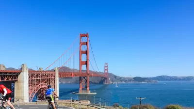
The Golden Gate Bridge District is looking at ways to improve safety on the bridge's narrow, windy bike and pedestrian paths.

According to data from the Marin County Bicycle Coalition and a Golden Gate Bridge District study, "a cyclist is five times more likely to crash traversing the Golden Gate Bridge as a motorist, and 21 times more likely to be injured." This indicates the need for improved bike and pedestrian infrastructure on the famous bridge, writes Roger Rudick.
The data shows that "there were 19 times as many solo bicycle collisions as there were bicycle-pedestrian collisions," partly due to newly installed fence slats that "amplify gusts, knocking cyclists over." The Coalition "is urging cyclists to participate in an outreach program, recently launched by the Bridge District, to get feedback and more information to figure out how to reduce crashes."
"[T]he District’s study, released last year, includes some specific improvements, such as: 'install additional high visibility wind warning signage along the west sidewalk to raise awareness' and 'implement a Standard Operating Procedure to shift bicycle traffic to the east sidewalk during hazardous wind conditions.'" The MCBC's assessment "also puts partial blame on Bridge District maintenance crews that use the path as a storage area," leaving less room for bicyclists to maneuver. "We are surprised to see that the study does not make any recommendations to increase clearances for two-way bike traffic going past construction material." Streetsblog comments that "crews would never regularly store materials in a motor-vehicle lane on the bridge, certainly not without significant traffic diversions and guidance. So why is a bike path seen as a suitable place to dump stuff?"
"MCBC is asking riders of the Golden Gate Bridge to check out all their recommendations, review the District’s study, participate in the outreach program, and take the Golden Gate Bridge District poll."
FULL STORY: New Push For a Safer Golden Gate Bridge

Bike, Pedestrian Toll on Golden Gate Bridge Survives First Vote
The concept of tolling sidewalk access to the Golden Gate Bridge squeaked by on a 10-9 vote on Oct. 24. The GGB Transportation and Highway District wants to consider the toll as a potential contributor to reducing the $33 million, five-year deficit.
Is It OK to Charge Pedestrians and Bicyclists to Cross Toll Bridges?
The Golden Gate Bridge, Highway and Transportation District might charge pedestrians and cyclists using the bridge in a plan to keep the district, which also runs buses and ferries between San Francisco and Marin and Sonoma counties, solvent.
San Francisco Reveals New Bike Plan
The draft plan targets improvements on 385 road segments.

Montreal Mall to Become 6,000 Housing Units
Place Versailles will be transformed into a mixed-use complex over the next 25 years.

Planetizen Federal Action Tracker
A weekly monitor of how Trump’s orders and actions are impacting planners and planning in America.

DARTSpace Platform Streamlines Dallas TOD Application Process
The Dallas transit agency hopes a shorter permitting timeline will boost transit-oriented development around rail stations.

Interactive Map Reveals America's “Shade Deserts”
Launched by UCLA and American Forests to combat heat-related deaths, the tool maps the shade infrastructure for over 360 U.S. cities.

Bicycles and Books — In Sacramento, Libraries Now Offer Both
Adult library card holders can check out e-bikes and e-trikes for up to one week.

Colorado Landfills Emit as Much Pollution as 1M Cars
Landfills are the third-largest source of methane pollution in Colorado, after agriculture and fossil fuel extraction.
Urban Design for Planners 1: Software Tools
This six-course series explores essential urban design concepts using open source software and equips planners with the tools they need to participate fully in the urban design process.
Planning for Universal Design
Learn the tools for implementing Universal Design in planning regulations.
City of Mt Shasta
City of Camden Redevelopment Agency
City of Astoria
Transportation Research & Education Center (TREC) at Portland State University
US High Speed Rail Association
City of Camden Redevelopment Agency
Municipality of Princeton (NJ)