


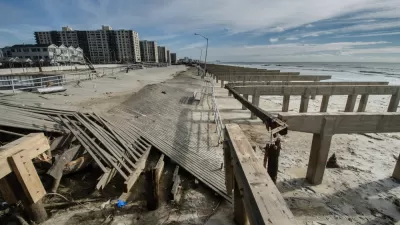
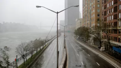
With 520 miles of coastline, New York City is ready to implement the lessons of Hurricane Sandy in the zoning code for the entire city.
New York Department of City Planning is seeking public input on a citywide rezoning designed to improve resilience during flood events. The new zoning rules are proposed in the Zoning for Coastal Flood Resiliency (ZCFR) process, according to a press release from the Department of City Planning.
According to the ZCFR website, "Zoning for Coastal Flood Resiliency would improve homeowners’ and business owners’ ability to withstand and recover from future storms and other disaster events. It builds on years of collaboration with floodplain communities to support post-disaster recovery and promote long-term resiliency."
The zoning changes proposed by the ZCFR process would update temporary zoning changes implemented after Hurricane Sandy in 2012, according to the same web page.
"The proposal would allow homeowners, business owners, architects and others to design resilient buildings that are better protected from flood risk and reduce flood insurance costs. It would protect and support public access to waterfront sites through resilient open space design. It would also help New Yorkers recover quickly from other future disasters, including the COVID-19 crisis," according to the website.
New York City Planning Commission Chair Marisa Lago is quoted in the press release with the following soundbite: "This new zoning also provides needed flexibility to address all types of future disasters, whether another climate event or today’s COVID-19 pandemic."
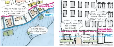
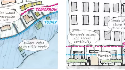
"Currently, buildings are restricted by zoning regulations that do not take resiliency into account and thus force New Yorkers to choose between interior space and resiliency improvements. ZCFR will make it easier for buildings to meet or exceed modern resiliency codes without sacrificing their basement, for example, by adding some much-needed zoning flexibility," reads the press release.
In one crucial component of the rezoning, the changes would limit the construction of new nursing homes in areas of high flood risk.
FULL STORY: Making NYC More Resilient: Public Review Begins for DCP’s Important Zoning for Coastal Flood Resiliency

'Zoning for Coastal Flood Resiliency' Wins Planning Commission Approval in NYC
Emergency responses to Hurricane Sandy have turned into long-term lessons in New York City, as the nation's largest city crafts a response to sea-level rise and extreme weather by making changes to the zoning code of coastal areas.
Zoning Reform for Coastal Resilience in New York City
The New York City Department of City Planning has released a large set of recommendations for zoning changes designed to help the city's many coastal areas weather the inevitable extreme weather events of climate change and sea level rise.
Saving Lower Manhattan
A debate over how to protect the East River waterfront from Sandy-level flooding and storm damage has delayed the project as community activists decry the city's last-minute change of plans.

Planetizen Federal Action Tracker
A weekly monitor of how Trump’s orders and actions are impacting planners and planning in America.

Congressman Proposes Bill to Rename DC Metro “Trump Train”
The Make Autorail Great Again Act would withhold federal funding to the system until the Washington Metropolitan Area Transit Authority (WMATA), rebrands as the Washington Metropolitan Authority for Greater Access (WMAGA).

DARTSpace Platform Streamlines Dallas TOD Application Process
The Dallas transit agency hopes a shorter permitting timeline will boost transit-oriented development around rail stations.

Renters Now Outnumber Homeowners in Over 200 US Suburbs
High housing costs in city centers and the new-found flexibility offered by remote work are pushing more renters to suburban areas.

The Tiny, Adorable $7,000 Car Turning Japan Onto EVs
The single seat Mibot charges from a regular plug as quickly as an iPad, and is about half the price of an average EV.

Supreme Court Ruling in Pipeline Case Guts Federal Environmental Law
The decision limits the scope of a federal law that mandates extensive environmental impact reviews of energy, infrastructure, and transportation projects.
Urban Design for Planners 1: Software Tools
This six-course series explores essential urban design concepts using open source software and equips planners with the tools they need to participate fully in the urban design process.
Planning for Universal Design
Learn the tools for implementing Universal Design in planning regulations.
Municipality of Princeton
Roanoke Valley-Alleghany Regional Commission
City of Mt Shasta
City of Camden Redevelopment Agency
City of Astoria
Transportation Research & Education Center (TREC) at Portland State University
US High Speed Rail Association
City of Camden Redevelopment Agency
Municipality of Princeton (NJ)