


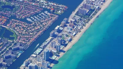
A climate change conference in Southeast Florida this week delivers bad news for communities on the coast in South Florida and in the Florida Keys. Some of those communities won't be saved as the receipts for climate change come in.
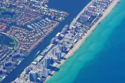
"The sea rise curves unveiled Wednesday at the Southeast Florida Climate Leadership Summit in Key West tack on about three to five extra inches by 2060, and that number only gets bigger in the future," reports Alex Harris for the Miami Herald.
"The region went from expecting between 14 and 26 inches of sea level rise by 2060 — commonly shortened to two feet by 2060 by local leaders — to predicting 17 to 31 inches of sea rise," according to Harris.
While Harris characterizes that news as not "catastrophically different than previous years," the focus of this article is on South Florida.
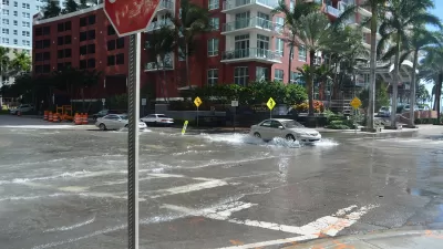
In an article by Christopher Flavelle and Patricia Mazzei for the New York Times, the news for communities in the Florida Keys is less diplomatic. Sea level rise is an existential threat, according to a report focusing on Sugarloaf Key, a small island 15 miles up Highway 1 from Key West, and released at the same event this week.
To keep those three miles of road dry year-round in 2025 would require raising it by 1.3 feet, at a cost of $75 million, or $25 million per mile. Keeping the road dry in 2045 would mean elevating it 2.2 feet, at a cost of $128 million. To protect against expected flooding levels in 2060, the cost would jump to $181 million.
And all that to protect about two dozen homes.
The larger, ethical questions raised by the report are debated in the article, and it's clear that decisions about who's property, and where, gets saved, will need to be made sooner than anyone anticipated.
FULL STORY: New projections show that South Florida is in for even more sea level rise

Miami Residents Resist the Idea of a 20-Foot Seawall
As climate change accelerates sea level rise and flooding in South Florida, locals hope to mitigate the impacts with less dramatic interventions.
Florida Real Estate Market Sounds Climate Alarms
New research suggests that real estate values were declining before prices started falling, but a climate-driven housing crisis could already be here in coastal Florida.

Managed Retreat in New York City
More and more New Yorkers will face the prospect of encroaching seas in the coming decades, and the unwanted choice of whether to stay or to go.

Planetizen Federal Action Tracker
A weekly monitor of how Trump’s orders and actions are impacting planners and planning in America.

San Francisco's School District Spent $105M To Build Affordable Housing for Teachers — And That's Just the Beginning
SFUSD joins a growing list of school districts using their land holdings to address housing affordability challenges faced by their own employees.

The Tiny, Adorable $7,000 Car Turning Japan Onto EVs
The single seat Mibot charges from a regular plug as quickly as an iPad, and is about half the price of an average EV.

Seattle's Plan for Adopting Driverless Cars
Equity, safety, accessibility and affordability are front of mind as the city prepares for robotaxis and other autonomous vehicles.

As Trump Phases Out FEMA, Is It Time to Flee the Floodplains?
With less federal funding available for disaster relief efforts, the need to relocate at-risk communities is more urgent than ever.

With Protected Lanes, 460% More People Commute by Bike
For those needing more ammo, more data proving what we already knew is here.
Urban Design for Planners 1: Software Tools
This six-course series explores essential urban design concepts using open source software and equips planners with the tools they need to participate fully in the urban design process.
Planning for Universal Design
Learn the tools for implementing Universal Design in planning regulations.
Smith Gee Studio
City of Charlotte
City of Camden Redevelopment Agency
City of Astoria
Transportation Research & Education Center (TREC) at Portland State University
US High Speed Rail Association
City of Camden Redevelopment Agency
Municipality of Princeton (NJ)